The Metropolitan Region Amsterdam (MRA) is getting busier and busier. Between 1990 and 2017, the population grew by one million and the number of tourists tripled. The length of train carriages was increased, train stations were improved and expanded. To travel short distances, many inhabitants take the car. Our online shopping behaviour also adds to the congestion, as it results in thousands of delivery vans driving in and around the MRA every day. All these aspects cause an increased pressure on the roads and railway lines. [1]
Between 1990 and 2024, we constructed approximately five hundred kilometres of roads.
We invested millions in building bridges, widening roads, constructing tunnels and relocating the A9 motorway, to name but a few. Despite all of that, the average travel time to cover 5 to 25 kilometres is an hour and a half. And the travel time within the MRA will only increase further in the years to come.
Use of public transport versus car by inhabitants of the MRA
Among the inhabitants of the MRA, the use of public transport has seen a percentage decrease. Currently, 55 to 60 percent use the car to cover a distance of 5 to 25 kilometres. However, when looking at the total figures, we do see an increase in the use of public transport. This is because the number of inhabitants, visitors and tourists who stay and travel within the MRA continues to rise.
No better alternative than the car
If we zoom in on the Amsterdam borough of Nieuw-West, it becomes clear that for most inhabitants there is no better alternative than the car to cover a distance of 5-25 kilometres. Obstacles include the low frequency of public transport, the distance to the train station, the long travel times of tram or bus, or the lack of bikes available through the OV-fiets bike sharing programme of the Dutch railways. The municipality of Amsterdam worked hard to transform Nieuw-West: buildings were repurposed and a lot of new buildings were added, housing trendy nightlife venues, restaurants and hotels. The borough where you wouldn’t be caught dead ten years ago is now the place to be. And this transformation within the municipal area is continuing in the whole region.
So what can we do to still get people from A to B in a quick, safe and clean way?
Is cycling the holy grail?
Not everyone is able or willing to get on a bike, or people consider the distance too great to cycle. And of course there are people whose car or van is indispensable: for work, as is the case for contractors for example, or for people with a disability. Some of the people who are looking for an alternative to the car are open to using an e-bike to cover a distance of 5 to 20 kilometres. But would they still get on that e-bike if it is raining cats and dogs?
Facilitating parking spaces
In large parts of boroughs and municipalities such as Amsterdam Nieuw-West, Almere, Diemen and Haarlemmermeer it is possible to obtain two (or more) parking permits. People accept the high additional costs of owning a car because they don’t have a better, quicker way to go to work or the place they are visiting. Until 2040, an additional ten thousand houses will be built in the borough of Amsterdam-West, most of which will have their own parking space, which in turn will have a big negative effect on the current congestion problem.
More infrastructure: the solution?
In the city of Haarlem there are plans for a tunnel that would pass under a junction in the city centre which is always congested. In this municipality, approximately 20,000 additional houses with parking spaces will be built. The tunnel will not solve the congestion problem in the long term, nor will widening the roads around the junction. They may help cars to leave the city, but the road will get congested again a bit further down. Because houses are built in all parts of the city, with more traffic as a result.
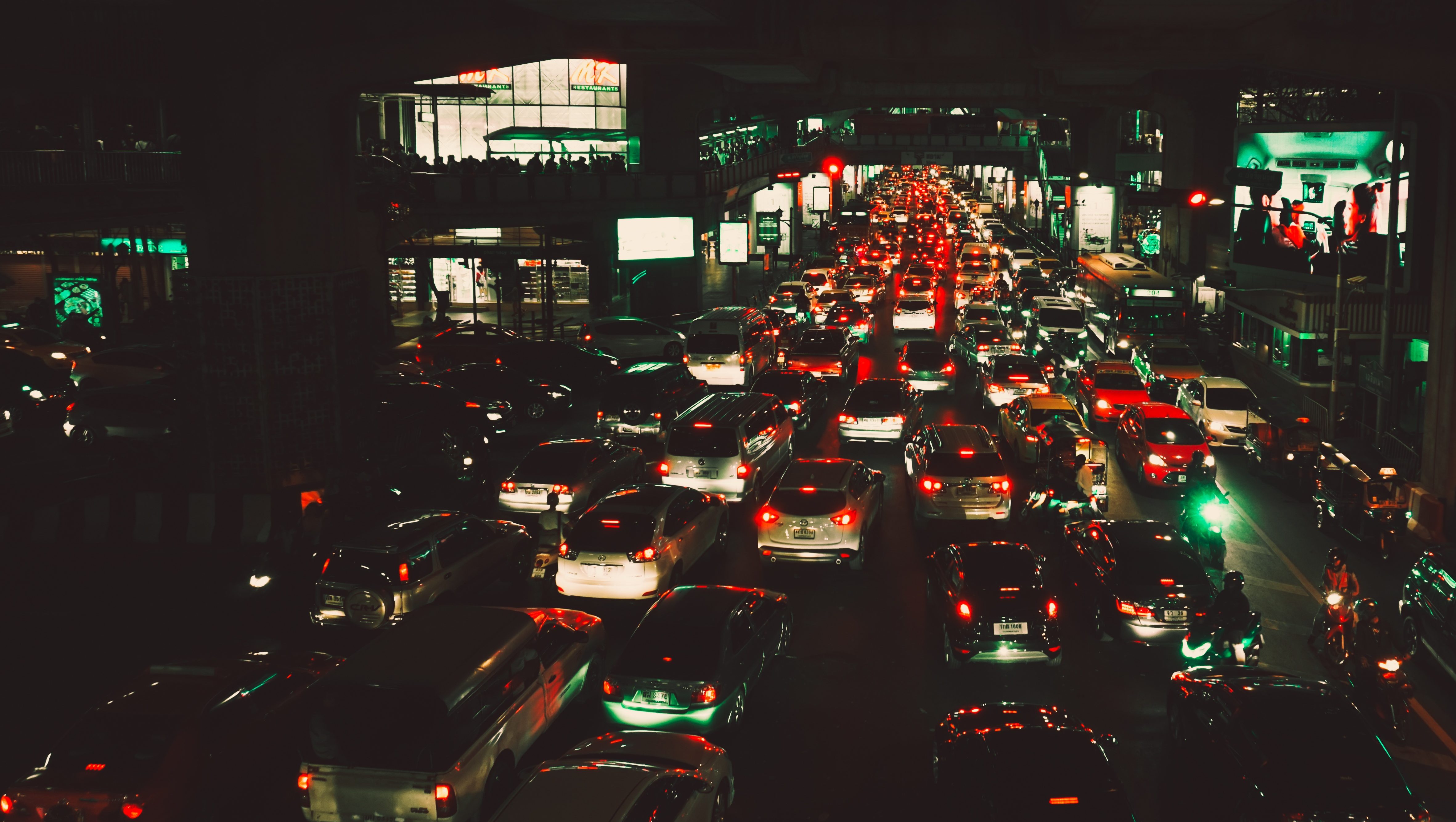
Traffic jams also occur in the city centre
On weekdays, it often takes an hour and a half to cover a stretch of 5-25 kilometres from A to B. There are traffic jams within the city and town centres of all municipalities, caused by the fact that the access roads are funnel-shaped. Access roads are the roads used to enter or leave town. It is not uncommon for it to take 35 minutes to cover the 500 metres to the access road. These roads are surrounded by houses and offices and can thus not be widened any further than they already are.
Order before 4 p.m. for delivery tomorrow
The average household can’t imagine life without online shopping anymore. In order to deliver all those goods bought online, the roads are filled with thousands of delivery vans, crossing the city centre and entering the residential estates. In 2016, these vans only constituted 5% of the total goods transport, but their share is increasing by approximately 25% per year. Ordering food online is also steadily becoming more popular. Both at home and in local restaurants we are increasingly looking for biological produce straight from the farm. And the farmer does not deliver by train or bike.
Schiphol airport and traffic
Due to its location, a lot of travellers from the provinces of Groningen, Drenthe and Friesland drive to Schiphol Airport via the A1 and A10 motorways. On average, the Dutch travel by plane three times a year; a weekend trip to Barcelona has become almost as normal as going shopping in Antwerp for the day. Many of these travellers take the car to go to Schiphol Airport, either parking there or getting dropped off and picked up by friends or family.
Even distribution of the tourists
In 2040, 16.5 million tourists are expected to visit the MRA. This will cause an increased pressure on the underlying tram network, the roads within the city centre and the motorways. The planned way to deal with this is to evenly distribute the tourists between the hotels in the whole MRA. However, all tourists want to visit the historical centre of Amsterdam at least once, so it won’t be possible to avoid the daily crowds in this area.
The use of buses and taxis by tourists
In 2016, approximately 13 million tourists visited Amsterdam. They don’t have a car here and most of them do not have any friends or loved ones to come and pick them up from the airport. They therefore use shuttle buses that constantly drive from Schiphol Airport to the hotels and back, or they take a taxi. The number of tourists who took a taxi from Schiphol Airport to the greater Amsterdam area in 2016 was 4.6 million.
Train connection from Schiphol Airport
In 2016, six million tourists used the train to get from Schiphol Airport to the city. In most cases, these people get told at the airport to go to Amsterdam Central Station. The fact that the connection between Schiphol Airport and Amsterdam Central Station or Amsterdam Zuid station are the easiest for tourists does not necessarily mean that that is where they need to go. Because in fact, the majority of accommodation is located in the middle of the city centre or outside the A10 ring road.
Public transport versus travelling by car
The problem with public transport is that it is not always possible to take a direct route to your destination, with the added risk of missing a connection during a changeover. In addition, you often have to walk or cycle for a bit to reach stations or bus and tram stops. In most cases, the travel time from door to door is more or less the same whether you travel by car or on public transport. The advantage of using public transport is that it is cheaper than owning a car and that you can do you what you want while travelling, without having to concentrate on the road. And direct connections often do exist, in which case you will gain travel time in comparison to travelling by car.
Is the train the holy grail?
The intercity train is heavy and takes time to slow down and pull out. More so than a lighter vehicle such as a metro, with which it is possible to achieve a frequency of one train every two minutes on the same track. And because the intercity train has double-decker coaches, it also takes longer for the passengers to get on and off, especially during rush hour. That can cause delays, which in turn can lead to annoyed passengers and queues on the track.
Is the bus the holy grail?
Line 346 between Haarlem and Amsterdam-Zuid station is a double-decker bus and uses a dedicated bus lane for part of the journey. The driver whistles happily while passing long traffic jams, until the point where he has to enter the city centre and is back to being stuck like all the other ‘normal’ commuters.
The high-frequency line 300 from Schiphol Airport to Amsterdam – and, in the near future, on to the beach town of Zandvoort – uses the longest dedicated bus lane in Europe. This bus is able to pick up speed and, with its high frequency, can be compared to the successful light rail network between the Hague and Rotterdam.
In the MRA however, most scheduled service buses do not have any lanes at their disposal that are fully dedicated to buses. Which means that they join the rest of the traffic in the queues. It is generally not possible to expand the network of dedicated bus lanes because – as mentioned earlier – there are buildings and houses alongside existing motorways.
Is the car the holy grail?
If you take the car, you don’t get wet when it rains and the children arrive dry at school and nursery, after which you can head to the office, listening to you own music while drinking coffee.
But the travel time by car is long and the car is more expensive when compared to travelling by public transport. Yet most households choose to have one or two cars. Besides the accessibility aspect mentioned earlier, this has also to do with what people are used to or grew up with. Without mentioning the status that often comes with having a (company) car. But what people don’t realise is that the growth prognosis of car traffic will eventually exceed the capacity of the motorways as well as the road capacity inside the cities.
More people means more traffic
Besides being a favourite with British, American and German tourists, Amsterdam is now also becoming a bucket list destination with people from Asia. Which means many more tourists are flying into Schiphol Airport, while the Dutch also increase their plane travel from that airport. And they all have to use the same road and tracks to get from A to B.
What does that mean in terms of problems on the motorways and in the city, with 300,000 additional houses planned, one million additional inhabitants and five million additional tourists by 2040?
It is thus becoming more and more important to look at the issue as a whole. Because a speed bump in street A has an effect on the traffic on main road B. An integrated and more direct cooperation between municipalities, provinces and the central government has become crucial.
MRA is a fact
The increase in passenger traffic will largely have to be dealt with by offering affordable, clean, high-frequent and fast public transport. If no action is taken, the current travel time of 1.5 hours will have doubled by 2040 and that is not the only problem. Besides safety and air pollution, just consider the effect of all those extra parking spaces that will be needed on the liveability of the public space.
The North-South metro line will start running this summer, and the East-West line is being planned, but these lines only offer connections within Amsterdam itself. There are however plenty of opportunities to extend several lines (partly by using existing tracks), thus connecting the rest of the MRA.
In short, the MRA is a fact. Just like the Paris Metropolitan Area is a fact. So what could the MRA learn from Paris in terms of accessibility, in order to offer the inhabitants a better alternative to travel more quickly from A to B within the MRA? I will tell you all about that in my next blog.
PS: Would you like to know more about the development, accessibility and solutions that are possible for your municipality or region? Geert Kloppenburg provides inspiring lectures on this subject. Please visit the tab Lectures on the website for more information.
Next time in The Written Vision: Line 1 Paris.
[1] For the growth prognoses we based ourselves on the high and low scenarios of the Future Exploration Welfare and Living Environment (‘Toekomstverkenning Welvaart en Leefomgeving’ or WLO), the results of which are included in the NMCA (National Market and Capacity Analysis) for the different ways of transport in the Netherlands.