Design road unsafety, how?

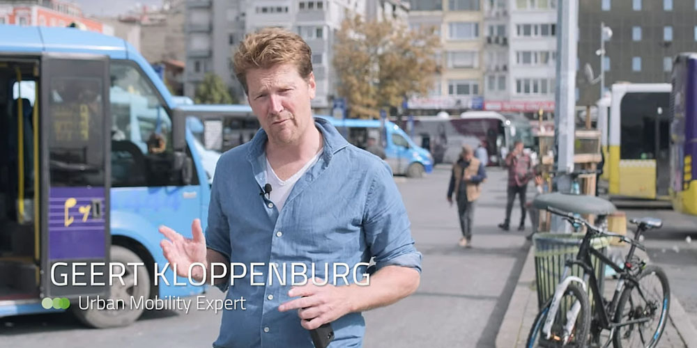
‘I keep thinking: am I going mad?’

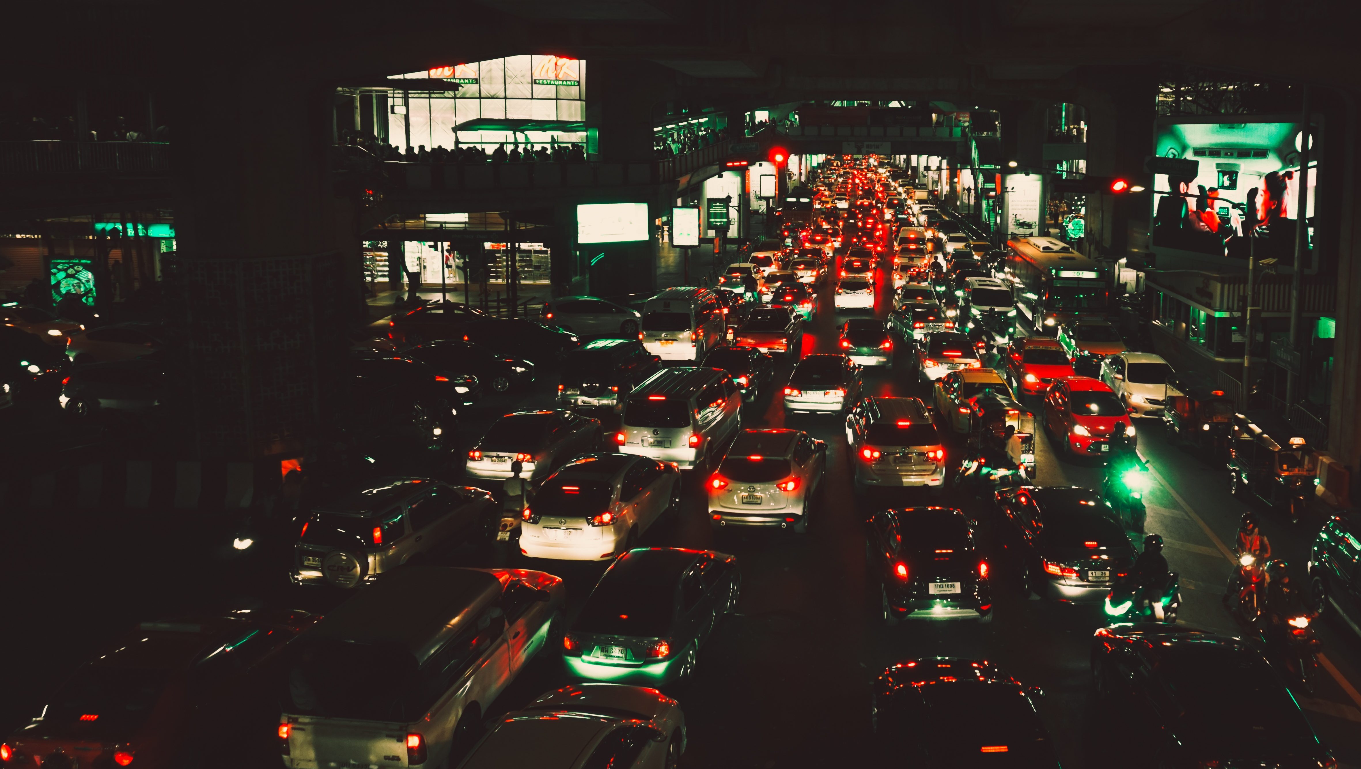
What is it like cycling to school at 8.15 in the morning, between rows and rows of cars and lorries? Geert Kloppenburg shows the traffic reality in videos containing countless close calls. “Who would design this?”

When Geert Kloppenburg roams the streets, the things he sees are very different to what local authorities describe in their policy papers. He gets on a bike, steps into a car, sits in the cabin of a lorry driver, joins a delivery driver during his rounds and he observes, observes and observes some more. And he films. Inspired by the findings of data guru Marleen Stikker, he demonstrates that the wrong kind of data is being used. “I keep thinking: am I going mad? I have been standing here in the rain for a while now and I honestly see something completely different to what is described in that policy paper. I know they talk about an average number, but that says nothing about the real danger of what is happening here.”

You mean: on average, only 0.1 pupil a year has a fatal accident here, but I see so many dangerous things happening here.
“Yes, this is a traffic situation both young and older people have to deal with. And that situation happens 250 days a year, every morning; that is what my new film is about.”
What Kloppenburg wants to show is that there is something fundamentally wrong. Cyclists, pedestrians, cars, delivery vans and lorries encounter each other too often. “That lorry driver would also rather be somewhere else. He obviously doesn’t set out to kill three elderly people. But if you consider the amount of traffic here, on a structural basis, then you can’t help but think: who would design this? At an intersection like that, the essence is not about who has the right of way.”

Always about behaviour
Kloppenburg feels for lorry drivers: “A lorry driver will say: ‘I can’t see a thing. That mirror will help me to see from here to there, but that’s it.’ And then when an accident has happened, they will say: ‘we did visit the school and explain about the blind angle.’ So that is what we do in the Netherlands: we send a police man and a lorry driver into the classrooms to explain that you should be careful when a lorry is turning. It is always about behaviour. Don’t use your mobile phone, don’t drink, use your lights. What we don’t do is analyse the situation, make a calculation of probability. Because this doesn’t just involve one intersection, it involves fifty intersections. That youngster, or that elderly person, will encounter that delivery van or lorry four times more. And that also becomes clear in the videos I made.”

Delivery vans
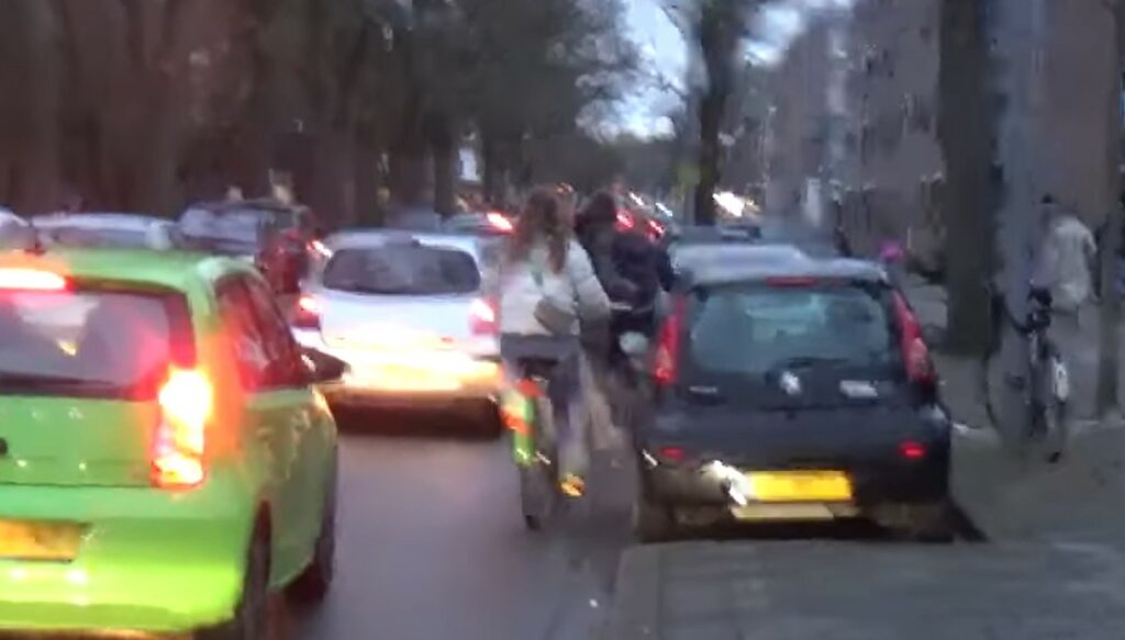
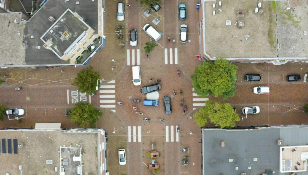
During his research, Kloppenburg realises that the situations he is pointing out cannot be deduced from the data of the local authorities. Take the delivery vans for example: the reality of those in the residential areas is not included in the policy papers. On several occasions, Kloppenburg joined drivers on their rounds. “That is when you realise what a nightmare it is and what happens on the phones of those drivers: ‘Parcel delivery street X, 9 a.m.; parcel delivery 9.10 a.m.; parcel delivery 9.20 a.m.’. Just think about how such a driver functions in the system [LH1] and about how many delivery vans are on the streets at any given time. Nobody realises it, but structurally there are fifty of those vans in a residential area at the same time, because loads are not combined. If you order on the internet, there are different delivery companies. You only see how many vans there really are when using a drone to look at the area from above. And what do the policy reports say? Delivery vans don’t drive many kilometres. That is not what you should be measuring, kilometres are not the right parameter. Those reports say that there are much less delivery vans than cars. But what counts is the number of movements. They constantly drive through the residential areas, every front door has become a shop and they do double rounds, meaning that at 7.15 p.m., when a child comes back from sports practice, they’re back in the area. That is not a single incident, that happens every day. Why do I not see that data in the policy papers?” The structural chance that someone gets hit in traffic has increased, says Kloppenburg: “Nobody calculates that chance. It is not about black spots (places where many accidents happen, Ed.), it is about the structural chance of someone getting hit. That chance has increased significantly.”

Why is that?
In the past 25 years, ordering things to be delivered has become extremely popular, so there are a lot more movements of delivery vans in residential areas today. Add to that the fact that the number of cars parked in those areas has doubled. There are more two-earner households, with two people travelling for work. Elderly people also travel more these days. And cars have become much wider and higher. And you can say ‘they have only increased by ten centimetres’, but in a city, ten centimetres is a lot. Just have a look around and you will realise how little visibility there is in those narrow streets full of parked cars.”

Black spots
In Kloppenburg’s opinion, traffic safety policy focuses too much on black spots. He wants to address the iceberg: the high number of accidents that are not included in the registers of the police and hospitals. “All those broken ankles, the falls due to a car door opening. That is the real elephant in the room. That massive category of accidents that are not classed as deadly or involving severe injuries. Insurers are aware of these, because they are the ones who receive the claims for car damage in these types of accidents. It is known that in the municipality of The Hague, there are approximately 350 of these accidents with cyclists and pedestrians every day. That is much more than we ever thought, it basically happens every day. But we don’t see that in the traffic safety statistics.”

Unacceptably high risks
“You could say that it comes with the territory, but I showed these videos to really good safety professionals. And the reaction of such a safety professional at Shell was: ‘if we would structurally let situations like the ones you describe happen here, the refinery would could have to close tomorrow. Our licence would be revoked.’ And a safety professional at the Dutch association for construction and infrastructure Bouwend Nederland said the same: that wouldn’t be allowed on a construction site, where everything evolves around eliminating risks.”

No more travel?
“People’s reaction is often: ‘so I can’t travel anymore?’. But that is not what I am saying. What I am saying is that currently too little is being done to eliminate the movements of time and place. To illustrate it, I will point to that sign saying ‘lorries allowed from 8 a.m.’. That really infuriates me. And this is what is happening in the whole country. Supply deliveries are allowed from 8 a.m., even when the delivery location is next to a school. Then you can talk all you want about changing behaviour and add another mirror, but if you tell them to come at 8 a.m. then that is what they will do. The design is not neutral, the problem is caused by the design. Behaviour is not the issue here. No, this is designed unsafety.”

TEXT: KARIN BROER – ILLUSTRATIONS: SIMON CORDES – PHOTOGRAPHY : PAUL VREEK/UNITEDPHOTOS AND DIGIDAAN

Taxi’s as part of the public transport system, how?

“Vans, more vans; are they van-mad here?”

[Intro] In his role as EIT Urban Mobility expert, Geert Kloppenburg went to Istanbul to figure out the dolmuş system. It turned out even more interesting than he had thought: 5000 vans, servicing 20 per cent of the public transport in this metropolis with 16 million inhabitants. “Why do we not have this in other European cities? A system that is flexible, demand-driven and unsubsidised!”

Kloppenburg has been in Istanbul for three days and is starting to know his way around the public transport system. For the last part of his journey to the town hall, where he will be carrying out an interview, he wants to take one of those vans that transport 9 people, a dolmuş. Because he has finally figured out how it works. He flags down what he thinks is one of those vans, but it turns out to be a school bus of which the driver is friendly enough to stop for this westerner who is frantically waving his arms. All the children on the bus are rolling around with laughter. But where should he have gone then? How do all those inhabitants of Istanbul know this?

This scene, which eventually is not included in Kloppenburg’s video about his trip to Istanbul, is a good example of his struggle to ‘completely and utterly’ understand the dolmuş system.  He has been mentioning the Turkish dolmuş vans for years as an example to follow. He used it in his book ‘De gulden snelweg’ (the golden highway), his vision for the future of public transport. The dolmuş system contains elements which remind him of the White Cart project of Luud Schimmelpennink, a member of the protest Provo movement in Amsterdam in the 1960s, who invented an alternative public transport system with electric carts. Kloppenburg is convinced that the dolmuş system offers opportunities for urban mobility, especially when using clean vehicles, but he had never actually researched the system in practice. So when, during a meeting of EIT Urban Mobility (the European initiative in the field of urban mobility) at the start of 2023, he got chatting to the head of transport for the Istanbul metropolitan area, responsible for transporting 16 million people, a plan was made: commissioned by EIT Mobility, Kloppenburg was to make a film about the dolmuş vans in Istanbul.

Willem Frederik Metselaar, director EIT Urban Mobility Hub West: ‘Dolmus has been around for a long time, but is also relatively unknown. That is why it is important to seriously investigate this system.’

Question: What attracted you so much about this system?

“The flexibility, the flagging down, the absence of a timetable. That also more or less summed up what I knew about it. It made me think of old-fashioned taxis, but at the same time it’s a form of public transport, which was a trigger for me. Is it really a form of public transport? Who drives these vans? And who decides their itinerary? Who decides how much you pay to use it? Is it possible to implement this in other European cities?”

Research

What followed was 7 months of research, video conferences and telephone conversations. Kloppenburg sent questions and requests to Istanbul, received notes, PowerPoint presentations, plans and maps, spoke to 30 Turkish public servants during a Zoom call, and so on, and so on. At the same time, the list with questions was growing.

“Three days before I left, the Istanbul transport department sent me a very short document, which very clearly stated: ‘There are 5,710 minibuses (max. 16 people) and dolmuş vans (max. 9 people), 170 lines and 460 routes, transporting 1.2 million passengers per day. These vans constitute 20 percent of public transport in Istanbul.’ 20 percent! That is massive. ‘In addition, there are 66,000 school and staff buses, and 20,000 taxis.’
So then you ask yourself: why do they have so many vans? Are the van-mad? Why did they not construct metro lines, like in Paris? And then you read about the risk of earthquakes, about the poverty after the Second World War, about how to solve things in a flexible way – the history of a city also determines the way certain systems are developed.”

The Sustainable Uban Mobility Plan or SUMP provided Kloppenburg with Istanbul’s vision of the future in terms of minibuses and dolmuş. Kloppenburg: “Comparing SUMPs is something I do regularly, that is more or less what my job is about. So where do those minibuses and dolmuş vans appear in here? They hardly do. Fascinating, this is all about railway tracks again. It really is the same old story everywhere. All those councillors and ministers always want train tracks, or a big bus because that is what they consider to be public transport. What are the plans for dolmuş vans and minibuses for 2040? The only thing they mention is integration with the Istanbul card, which is in fact a very good idea.”

What is the itinerary of those vans?

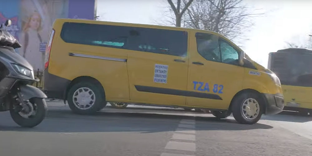
After all that preliminary research, it is time to visit Istanbul in October. As always, Kloppenburg arrives in town three days before his first interview. Now, where to find those dolmuş vans and minibuses? He sees blues vans, yellow vans, all sorts of vans, but what is what? Kloppenburg: “In the end, I just got on one, thinking ‘I’ll soon find out’. And it went in the complete opposite direction of what I had intended. I didn’t understand how much I had to pay, I didn’t understand which lines there were, where the starting points were – I quite simply didn’t understand one iota.” He did not have a map of the network. Eventually, he figured out that the lines could be found on Google maps.

One day before the first interview, Kloppenburg was in a slight panic: how was he supposed to ask good questions if he still had so much trouble understanding this system? “So I called my Turkish camera man and asked him if he could come and join me. Because he spoke very good English. So I made one entire journey with him and he explained to me how the whole system works. He uses it a lot himself, as does his family. Everyone, old, young, poor or rich, uses dolmuş vans.”

During this journey, they had a long conversation with a driver. “He told me that they scale up and down at their own initiative. Meaning that if it’s busy, another van is added.” The drivers are self-employed. The rates are set by the government. So the money is for the driver, but the rates, normal public transport rates, are set by the government. What did the driver think of that?  “He said that actually, the cooperation works really well. As an outsider, you would think that those drivers would want the rates to go up, but that taxi entrepreneur said: ‘I don’t want the rates to go up, because that would make me lose too many customers.’ What is a problem now however, is the staggering inflation, causing the petrol price to skyrocket. The drivers in the regular public transport network are not effected by this, they are all employees.”

But the dolmuş drivers are generally self-employed; if they are ill, they call a colleague. Kloppenburg: “It is very similar to the TCA taxi centre in Amsterdam: one car, driven by four drivers. What makes it special, is that they are part of the public transport system. That really is unique. The government sets the rate and decides the itinerary of the line.”

We Dutch being arrogant, we quickly think that the dolmuş system only works in Turkey because they don’t earn a lot of money over there. Kloppenburg: “But that is not the case at all, those drivers earn a normal wage. If you were to compare it to the Dutch situation, they earn a normal drivers’ wage as negotiated by the Dutch trade union.”

Kloppenburg and his camera team film for ten days. He visits the farthest corners of Istanbul, the places not a single tourist goes. He sees minibuses coming and going at one of the stops of Istanbul’s impressive Bus Rapid Transit line, the metro bus. He interviews the head of the dolmuş system, who is actually quite surprised that a Dutchman has come all the way to Turkey to look at a system which the Turks don’t find all that special and consider a bit old-fashioned even. He crosses the city, on foot, by bike, by public transport, by car. And he discovers the strength of the metro bus which crosses the metropolis fast and frequently on its dedicated bus lanes, servicing 9 percent of all public transport with just a single line.

Question: What are the big advantages of the dolmuş system?

Kloppenburg: “It is a system that works as a feeder for, for example, the metro bus and the train, but it also works as a stand-alone system. One line often branches out to become three lines further down. The dolmuş van can stop anywhere it likes. The fact that it is so ramified is one of the big strengths of this system, including for the elderly, for example, who have difficulty walking. The system is nearly door-to-door. All the addresses on a line are stops. And if you see how many lines there are, and how many addresses you thus reach, that makes an incredibly ramified system.”
Another big advantage is the flexibility. Kloppenburg: “The whole network could start using different streets tomorrow. That’s something that is impossible with railway tracks. And the vehicles are flexible: more vans, less vans. You can very easily scale up or scale down as needed.”

At the end of the film, Kloppenburg concludes that this dolmuş system is interesting for other European cities. “It is part of the public transport system, once the Istanbul Card has been integrated you can use the whole public transport network with just one card, and the system is not subsidised (there is no cash-out system). Generally, public transport requires public investments or a subsidy, but this system is self-sufficient with the rates and itineraries still being determined by the government.” Those are all advantages, which will increase even further if the system were to be improved at certain points. Kloppenburg: “Now just imagine that we combine this system with clean vehicles and more space on the road through dedicated lanes – that is when we are really cooking on gas, creating a system everybody has been waiting for.”

KB

Part two: Why the dolmuş system would be a suitable solution for European cities, such as Amsterdam.

How do you get through the jungle of booking/planning international traintickets?

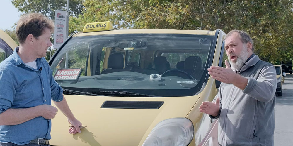
One out of three flight itineraries within Europe can also be done by train in less than six hours. Still millions of Europeans prefer to fly. This is mainly because the fantastic European public transport systems are all just a few stops short of being interconnected. And because it is incredibly complicated to plan, book and pay for an international train journey. In the past year, I investigated the issues people encounter when wanting to travel through Europe by train – and found out how we can simplify things.

Imagine this scenario: I’m a PSV supporter living in Roermond. After years of misery on the field, my club is finally back in the Champions League. They kick off against Arsenal in London, on a Wednesday evening at 8:45 pm. I moved heaven and hell to get tickets for my son and me, and now I have to figure out how to get there. What do I do? The easiest would be to drive to Düsseldorf or Eindhoven and then fly to London using Ryan Air. But: I have decided I don’t want to use planes anymore when travelling short distances, I want a greener alternative. So I will take the train this time. This is the type of scenario I have been playing with for hours on end in the past year. What kind of problems do people encounter? The result was even more absurd than I had already feared.

The hell of planning, booking and paying

The first step is to plan the journey. I tried Google as well as the travel apps of Omio and NS International. Omio indicates that I would be best flying over. That would take me from Eindhoven to London within an hour (but note: this does not include the thirty minutes travel to get to Eindhoven, the two hours needed for check-in, customs and luggage, another hour for customs and luggage plus an hour on the train to get to the city centre). Google and NS International do provide an option to go by train. This involves travelling north (!) first to Rotterdam, to then take the Thalys to Brussels and then transfer to the Eurostar to get to London. A journey of approximately six hours. You can see the itinerary in the image.

One would think there is a smarter way to do this; by car I would drive to Brussels via Maastricht, so I am going to try to do the same by train.

And that is the point at which I am really baffled: First I have to take the train from Roermond to Maastricht, using my OVchipkaart. Then I have to get off the train to check out with my chipkaart and buy a separate ticket to Liège, or use the app of the Belgian railways NMBS to buy a ticket. Once I have purchased that ticket, I am stood waiting for the stopping train between Maastricht and Liège, which passes once an hour and makes four stops on the way. And for the stretch between Liège and Brussels, I only have three options: one train in the morning, one in the afternoon and one in the evening. None of them offer a proper connection to the first part of my journey. Now, because I spend more time looking into mobility issues than the average person, I know it can’t be right that there are only three options here. Because every hour, there are four intercity trains travelling between Liège and Brussels. Our PSV supporter would probably have given up by now, but I won’t!

When I have another look at the NMBS app I find the intercity trains which I was unable to find in the international planning apps. So I take one of them to travel to Brussels. Once on the train, I have a look at my ticket (the third one since I left home) and get a scare: is the final destination of this train Bruxelles-South, or should I have gone to Bruxelles-Midi station?

Much to my relief, they turn out to be one and the same and I will be able to catch the Eurostar from that station shortly. A few minutes later, I hear the voice of the train guard over the Tannoy: we’re delayed. So I call Eurostar to ask if it is possible to take a later train than the one I booked, but they tell me that unfortunately, that is not possible. Eurostar is not responsible for any delays on the NMBS system, so the problem is mine, not theirs. I have no choice but to fork out € 184 for a new Eurostar ticket. When I board my last train at 6.56 pm (six hours after I left Roermond), it takes me to London within the hour without any problems.

The three major issues of international train travel

Does this example sound like a dystopia? Or a scenario that just happens to fit this article? Then I suggest you try it yourself once. In the past few months, I spent a lot of time planning and making tens of different train journeys within Europe. From Bordeaux to Barcelona, from Zwolle to Düsseldorf, from Turin to Lyon, from Basle to Brussels, to name just a few. Sometimes, everything goes smoothly. But I also found three recurring problems.

  1. Traveling from capital to capital is easy. Using any other start or end point almost always means trouble 

    It is not a coincidence that the stretch Brussels-London was the easiest part of my journey from Roermond to London. Because travelling between capitals hardly ever poses issues. The majority of the problems arise when your starting point is not a capital. Amsterdam to London is a piece of cake with a direct train that only takes 4 hours – Roermond to London much less so.Generally speaking, this makes sense. The strategy of international train travel is focused on fast main lines. From one area with many people to another area with many people, without too many stops on the way, as you are competing with a plane.

But because all the focus in on the above, you get absurd situations. If for example you want to get from Heino in the Dutch province of Overijssel to Düsseldorf in Germany, you currently have to take the Arriva train to Zwolle, than catch a train from Zwolle to Arnhem to then wait for an international train that only passes four times a day. We see a similar thing when travelling between Bordeaux and Bilbao, or between Toulouse and Barcelona, and many other European border crossings. There is undoubtedly a smarter way (carry on reading to find out how), and enabling this is imperative, as most Europeans do not live near or in a capital.

  1. The apps of public transport companies such as NS, DB, Trenitalia and others mainly promote their own network

    If you use the apps of the public transport companies when planning your journey, you only get to see a very limited selection of what is on offer. I found a clear example of this when planning my journey back home to Zandvoort after a work trip to Milan. By way of an experiment, I had purposefully not booked my journey in advance, which very much displeased my travel companion Gerson, who saw the ticket prices increase by the day.When we tried to plan our journey on Friday morning, the apps showed us that all travel options between Paris and Amsterdam were sold out. How was that possible, given that there are TGV trains every hour between Paris and Lille (taking 1 hour), between Lille and Brussels (taking 2 hours) and Brussels and Amsterdam (taking 3 hours)? But the apps of Trenitalia, NS, Thalys and Omio did not show us those options. It was only when using the SNCF app that I stumbled upon a beautiful train network, which obviously does exist. This app showed me that we could also travel via Disneyland Paris, which was a much more attractive option as it means avoiding the infamous transfer at Paris-Nord station. And that was a real bonus for my travel companion Gerson, who has trouble walking.So in the end, there was a way. But in order to find it, we had to think of the options ourselves and know exactly which app to use or be crazy enough to just try them all.The train companies are state-owned and mainly focused on their own market, which is something the Council for the Environment and Infrastructure (Rli) has also pointed out in its report Verzet de Wissel (Change the switch). They try to protect that market, which results in travelers not being given all the options, while they do exist. Examples are the French and Czech railway companies who only offer the cheapest rates on their own websites. And some public transport companies, such as the Hungarian railways, do not work with foreign booking sites at all.

  2. As soon as you have to change between trains of different providers, you’re in trouble (and you, the traveler, don’t have many rights)

    Protecting your own market equals a lack of cooperation, which in turn means that the traveler soon becomes the victim. While it only takes a few clicks to book a flight ticket between Milan and Amsterdam on Skyscanner, I had to buy my train tickets through Trenitalia, SNCF, ROR and NS. Each with their own booking system, terms and conditions and rates. It means you can’t just buy your ticket for the journey in one go, which causes problems in case of delays. If one of the providers is delayed, the other will not just let you take the next train.

Short video, where I show the potential of connecting existing train networks


Why is that a problem?

It is mainly a problem because it doesn’t have to be that way. Most European countries are served by an incredible network of intercity trains. Rails are in place and the capacity is there. So we have all the ingredients to give 550 million Europeans the chance to move through Europe in a much greener way. All it takes is giving everyone access to a European train network, which would enable people to reach their holiday or work destination abroad with just two or three simple transfers. It avoids having to queue for hours at the airport, and while on the train you can do some work, enjoy the passing scenery, play games, meet people in the on-board bar, not to mention the fact that you get off in the middle of town. That’s how good it could be.

But currently, more than a million people per year travel by plane to get from Paris to Frankfurt and back, and more than two million people do the same for the stretch MadridBarcelona. A quarter of the European CO2 emissions from aviation come from flights of less than 1500 kilometers long. If those figures stay like that, we will never achieve the climate goals. Especially when you bear in mind that there are currently a lot of Europeans who are not travelling by plane because they cannot afford to.

In a social Europe, mobility should not just be for the elite. But at the same time, we want flight traffic to decrease instead of increase. So we have to start doing things differently and the train plays an important part in this. There is an alternative by train for 34% of the busiest flight itineraries in Europe, with a travel time of less than six hours. And if you calculate the costs from door to door, travelling by train is often not more expensive than flying. The most important thing we need to do, is make things easier for the traveler, much easier. And that is feasible, without having to invest billions in new railway lines.

The most important changes do not cost billions

Connecting existing networks: carry on until the next hub

It was my biggest frustration during my trip from Roermond to London: the fact that the NS train stops at Maastricht, rather than in Liège, for example. If that train would just carry on for another half an hour, it would take the travelers straight to an international hub, from where they can continue to Paris, Frankfurt, London or Berlin. But instead I had to stand on a cold platform and wait for a stopping train. The point I am making here became crystal clear to me when I came across an Interrail map while doing my research. This map shows the network of trains that remains so craftily hidden when you try to book your journey via all the different apps. This map shows the magical world of possibilities that would emerge if we would connect the existing train networks just that little bit better, by extending them to just across the border. A world in which even people who do not live in a capital would be able to easily reach the next hub, from where they can get to their destination quickly and without any trouble.

Simplify the planning, booking and paying process

At the same time, it should become possible to plan, book and pay for your European train journey with the use of just one app, which shows all options. Arriën Kruyt, member of the European Passenger Federation, makes it painfully clear why this process is currently so difficult.

It’s because there is already a system that makes it possible to show all available options and compare them. It’s called Amadeus, the system that is being used by websites like Booking.com or comparison websites for mortgages or flights. This same system was offered to all railway companies years ago, but the negotiations are still ongoing. The parties can’t come to a consensus, mainly because all providers want to promote their own trains and not those of the competition.

In my opinion, there is only one way to break free from this situation: European laws and regulations. While I am finishing this essay, I come across a promising interview with Frans Timmermans, vice-president of the European Commission. He says that European railway companies have until the end of the year to come up with a joint ticketing system. “If they don’t, then we will legally impose it,” says Timmermans.

That is exactly what we need, but I’m not holding my breath. After having spoken to more than twenty prominent experts on international train travel, ticketing and Mobility as a Service (MaaS), I have concluded that there is no lack of good intentions at the European Commission. It’s just that so far, there has not been enough urgency and knowledge to break through the lobby of the state-owned companies. European Parliament has already tried to improve the poor passenger rights in case of delays, but the regulations were toned down in the European Council after a strong lobby by the railway companies.

I think we cannot afford to let that happen. On a yearly basis, there are 144,220 airplanes that fly to and from Schiphol Airport for flights of less than 500 kilometers. More than a million people per year travel by plane between Paris and Frankfurt and more than two million between Rome and Paris. How is it possible that we can agree on using the same currency, but we can’t manage to make train travel more attractive by just creating one good booking system?

Let’s reserve one of the billions that we invest in rails for that. Oblige all providers to share their data, sell tickets of other providers and take over from one another in case of delays. I am convinced that those regulations and that this one billion will have just as much impact on European train traffic, as all the other billions.

Whether you’re from Greece, Germany, Belgium or Lithuania, everyone should have the opportunity to travel through Europe in a decent and sustainable way. To plan their journey and use the same ticket to open all the gates. With a simple system which everyone understands. No worries, no stress and a much nicer travel experience than they would have had when travelling by plane.

And all that without a drop of kerosene.

By: Geert Kloppenburg

Download the entire essay in .pdf format from this link

5 things to highlight when talking about mobility in Paris

On 26 July, the Olympic games started in Paris. Mobility expert Geert Kloppenburg has been visiting the French capital since he was a little boy and made several videos and podcasts about mobility in this city. In his view, what are the things to be highlighted when talking about mobility in Paris, or more specifically, in the Paris Metropolitan Area?

‘When it comes to mobility in Paris, the traditional view is to highlight the rail network,’ says Kloppenburg. ‘”Just look at the fantastic RER network and beautiful metro network they have, and look at how many stations there are and how the system is high-frequent.” And then, upon our return from a visit to Paris, we say: “We should invest billions of euros more in the expansion of metro, tram and train as well. And look, they have the Grand Paris Express (an gigantic project of new lines, expansion of existing tunnels, new stations), costs: 35 billion.” But if you look at the grand scheme of things, the biggest change in Paris in recent years has been the bicycle.” So what should be highlighted?

  1. The bicycle and more importantly, the fact that cars have been pushed out

‘To me, the story of the bicycle in Paris deserves prime position, that story is massive. The transformation in the past ten years within the Périférique, from ‘unthinkable’ and ‘does not stand a chance’ to the truly gigantic steps forward that have been made on all levels. No, of course it’s not perfect yet and it’s certainly not as well-organised as in the Netherlands, but if you look at it with the former Parisian situation in mind, then it is mega. I made two videos with Christophe Najdovski, former deputy mayor. The first steps forward they took in Paris were enormous, by transforming car infrastructure into cycle paths. Like along the Canal Saint-Martin, where you can now find many cyclists each day. And along the river Seine they transformed a car tunnel with a daily passage of 40,000 cars into a bicycle tunnel.
Another impressive feat is what they have done with the streets surrounding schools. Car traffic in areas around schools has been made physically impossible. Not just during the drop-off and pick-up times, like we have in Amsterdam, but all the time, day and night. And not in just a few of those areas: there are lots of them and the effect is truly amazing.

Ok, they have not yet managed to change the Périférique – which is comparable to the A10 ring road around Amsterdam – into a city road, but they are looking into it, to dynamically close lanes for individual car traffic and open them for buses and taxis. That could be very relevant for the A10 around Amsterdam and the ring road around Rotterdam as well, and the Ministry of Infrastructure and Water Management is currently researching this, as an alternative to expansion and constructing tunnels.’

  1. The logistics

‘The logistics and the consequences of the order economy, that is something they have really understood in Paris. I made a podcast with Philip Christ, an expert of the ITF (International Transport Forum) about the logistics of Paris. That is a topic which receives far too little attention. In Paris they say: “If we can’t get a handle on that order economy within the Périférique, with the thousands of different delivery drivers of internet parcels and all those suppliers of shops, restaurants and offices, then traffic in this city will become simply impossible.” They already saw that coming in 2018.
And now you can see that they made all sorts of changes: hubs next to the city centre, bus terminals which are also used by freight traffic during the day, new logistics complexes and a logistics hotel such as Chapelle international, where freight trains enter the hotel for the containers to be unloaded or transferred (see https://www.managementsite.nl/de-laatste-meter/stadslogistieke-lessen-uit-parijs-logistieke-hotels in dutch).

When I visited Paris with the chairwoman of the mobility executive committee of Amsterdam, I pointed this out to her. Due to the enormous scale and volume in Paris, they can’t just leave things be, because that will inevitably end in chaos. More attention should be paid to this. Don’t forget that in the Netherlands we already have a million delivery vans on the roads as well, and in terms of movements and time, they are mostly in the urban areas. 10 years ago, there were only about 600,000. That’s how quickly it goes.

  1. Automation of metro lines

‘I have to give a railway example after all. But I think that the automation of two metro lines (lines 1 and 14), which has been operational since 1997, is a story that needs to be told.

Why? Firstly, because when there are strikes, line 1 and line 14 always continue their service as usual. And secondly, because it’s more flexible. You can deploy more carriages when it is busy and when it is quiet, you can easily remove some carriages – you’re not bound by the work schedules of the staff. And the last reason is of course the big pressure on the labour market due to the ageing population, which causes a shortage of staff in all lines of work.’

  1. The bus

‘My mother always used to say: “If you go to Paris, take the bus because you will see much more like that. Don’t spend your whole day underground.” And that’s when I noticed how nice the bus network actually is. And also, how important it is, also in a city like Paris. Not everyone is able to cycle and for a local errand and distances within the Périférique, you don’t always feel like descending 20 sets of stairs.
You could say: “We need to make everything accessible and wheelchair-friendly, and all the lifts need to work,” but we also understand that for a distance of 800 metres, or just going up or down the hill, many elderly will take the bus.’

  1. The connections between suburbs, ten million people outside the Périférique

Part of the Olympic Games took place in the suburbs, like in Saint-Denis where the Stade the France is located and where they built the Olympic village. Not far from there they have now built the Gare Pleyel, which is part of the Grand Paris Express project. One of the explicit goals of the Olympics in Paris was to also let the banlieu benefit.
And there are also big investments being made in other Parisian suburbs, which are known for poverty, disadvantaged neighbourhoods and criminality – investments in housing, in education, in employment and also in transport. In recent years, Kloppenburg regularly visited these suburbs, often together with urban planner Rob van der Bijl, and once he even dragged an entire delegation of the municipality of Amsterdam to Grigny, an infamous suburb in the southern part of the Paris Metropolitan Area.

Why? Kloppenburg: ‘I’m all about investing in public transport for social reasons. And about the multi-core structure of the Paris Metropolitan Area and the choice to strengthen what we call the tangential connections, the connections from suburb to suburb. Because they are heavily investing in those connections.
You have to really take into account the scale of Paris: Paris within the Périférique has 2 million inhabitants. But in the Paris Metropolitan Area live approximately 12.5 million people. What they usually give you as a tourist is the Plan Metro, which only goes as far as the Périférique and just beyond. Then there is the RER network, which are the suburban trains, and there is also a tram network in Paris (which many people don’t know about, I didn’t either) and there are buses: fast buses and slow buses.
And if you put all those different networks on top of each other and look at the places Paris is investing in, where those 35 million are going, then you can see what they are doing. It’s much more about creating connections between the suburbs, which also serves to relieve the network in the city centre. They are creating fast bus connections from suburb to suburb, and expanding the tram network, such as with the T1, T2 and T3. And all of this is outside the Périférique.’

Why is this relevant for Amsterdam?

‘It is relevant for the greater Amsterdam area, so Amsterdam plus the suburbs – Geuzenveld, Osdorp, but also Zaandam, Almere, Weesp, Diemen, Amstelveen. Approximately 150,000 people live in the Nieuw-West district, and new houses are still being built. We increase the density, but not in the city centre; we are increasing the density on the other side of the A10 ring road.
And if you then take a look at our public transport network, you immediately see that in a district such as Nieuw-West, or Amsterdam Noord or Rotterdam-Zuid (with 220,000 inhabitants!) there is very little public transport, and that the public transport network is concentrated in the city centre. The tram network in Amsterdam is concentrated in the city centre, which makes sense as it dates from as early as 1875. And the Noord-Zuid metro line takes you from Amsterdam Noord to the city centre, but not to Zaandam and there are no connections from east to west within the Amsterdam Noord district.

In the Netherlands, a lot of money destined for public transport is used to improve the mobility of students and pupils, and much less that of people living in the suburbs. So how do you get from Nieuw-West to an industrial estate at night in the rain in November? And how do people from the suburbs get to work at Schiphol airport early in the morning? Or how do people from Rotterdam-Zuid get to the greenhouses in the Westland?

But, things are starting to change – in Paris but also in the Netherlands. Policymakers now say: “We need to start doing more in those districts.” That’s a positive development. But views differ on how to do this. For me, the solution does not have to be a 19th-century tram. In cities like Paris and Istanbul, the volumes are so high that you can’t really go without strong collective systems such as buses or trams. But that’s not the case in the Netherlands.
Although when I’m in Paris, I also often think: why is the asphalt so little used by public transport? And with that I mean the motorways, so the A86 and the Périférique, in particular. In Paris, the public transport mainly consists of railway lines. Expanding those old systems costs an incredible amount of money. While a lot more can be done by, for example, dynamically reserving lanes for public transport – for buses, sharing systems and/or dolmuş vans. With the emphasis on dynamic, so not rigid and exclusively for a scheduled GVB bus service once every 15 minutes.

Look at how they created the streets around schools in Paris – by pushing out the cars. Look at how they made space for the bicycle – by removing the cars. That is possible, and that does not cost 35 billion.’

Why investing in the same road and rail projects is not the solution?

If the government continues to just solve pressure points on the road and in the railway system, that will eventually only create more cars and thus more pressure points. It is about time for us to start using our billions of euros for infrastructure in a different way. And then immediately take into account the effects of roads, such as road casualties and environmental damage. Because there are solutions that are more effective, cheaper and healthier than simply putting down more asphalt, cement and iron. More bicycles, more people in one vehicle and building in the areas around train stations are but a few examples.

What is the problem? Everything starts with the Multi-year programme for Infrastructure, Space and Transport (Meerjarenprogramma Infrastructuur, Ruimte en Transport or MIRT). This programme contains the projects of the central government and the regions for the creation of roads, railway lines and waterways, ranging from simple ring roads to gigantic projects. In the next few years, the total budget for approved projects will be 8.9 to 9.1 billion euros per year (including the management and maintenance of railways by ProRail and of roads by the Ministry of Infrastructure and Water Management). That money will come out of the government’s fund for infrastructure projects called Infrastructuurfonds. The MIRT expires in 2032, meaning several future governments will be involved.
The regions (the four big urban areas in the Randstad conurbation, but also Arnhem/Nijmegen, Eindhoven, Groningen and Twente) barely have money of their own to adjust or create infrastructure. For projects of a decent size, the regions have to ask the central government for money, which then decides how the available budget will be divided. In practice, this means that large infrastructure projects of the central government get priority, with little money left for the regions.

1. Cash withdrawals for pressure points only
To put it bluntly, the MIRT is the ATM of the government: if you need any money for infrastructure projects, that’s the place to go. Problem 1 is that regions are only allowed to ‘withdraw cash’ if they can prove they are dealing with a pressure point. A pressure point is the weakest link in a piece of infrastructure. For example, places where different types of transport cross each other, places where the traffic flow stagnates or bottlenecks (where the roads changes from three lanes to two, or the railway from four tracks to two).
So how can a region know if the situation they are dealing with is a pressure point? This is decided every four years in the ‘National Market and Capacity Analysis’ (NMCA). That NMCA uses traffic models to determine where there will be pressure points in the coming years. Traffic models are computer programs which estimate how traffic is divided between destinations, types of transport, times of day and routes.

2. Car and public transport interchangeable?
It is common knowledge that if you use a model, the output is dependent on the input. Which in this case means 25 years of stagnated traffic and transport policy, with cars as star of the show. And that is problem 2 of our infrastructure policy: policy makers start from the assumption that cars, public transport and bicycles are non-communicating vessels. But thanks to innovations such as the e-bike or the OV-fiets bike sharing programme and more frequent public transport through systems such as ‘A Train Every Ten Minutes’ (for the intercity train between Amsterdam and Eindhoven), RandstadRail (express trams) and R-net and Q-link (express buses), we see that motorist abandon the traffic jams and start using alternatives. So it is possible to change travel behaviour after all, as long as the alternative is good enough.

3. Fictitious economic value
Traffic models mainly focus on travel time. Travel time lost due to pressure points. And travel time saved thanks to infrastructure projects which are supposed to solve those pressure points. The measure for travel time lost is the lost vehicle hour or LVH. One LVH can mean that one vehicle has a delay of one hour on a specific trajectory. Or that six cars are stuck in congestion for ten minutes. But what is not taken into account is how many people there are per vehicle. Models count vehicles, not people. In traffic models, one luxury taxi van or a minivan with 10 passengers is weighted in the same way as a car soloist: one individual car with just a driver. Which is problem number 3.
Every lost vehicle hour is attributed a fictitious economic value for the user. For example: an hour in the car for a business man or woman is worth over 26 euros. A commuter on the train is worth 11,50 euros. And for the moment, a commuter using a bicycle is worth 0 euros – according to the models, that is. As a region, you can rake in more money for new infrastructure if you send 1,000 people as car soloists through the Coentunnel bottleneck, than if you divide them over 100 luxury taxi vans or minivans. So on paper, the economic value of those 1,000 people is ten times as high when they each drive their own car as if they were divided over taxi vans. And if you would put them all on an e-bike, they would have no economical value at all.
My father was a cardiologist at the Kennemer Gasthuis hospital in the city of Haarlem. According to the government, his commute by car from our house in the neighbouring village of Aerdenhout to the hospital in Haarlem has economic value. But doing that same trajectory on an e-bike would have no value at all? And that while it would be quicker, cheaper, take up less space on the road, cause no pollution, not to mention keep him in good shape?

4. Flattening peaks through infrastructure?
But when is a pressure point considered a pressure point? It turns out that the peak, meaning rush hour, is decisive. Most people only sporadically lose time in traffic congestion, according to the report ‘Blik op de file‘ (View on Traffic Congestion) of the Netherlands Institute for Transport Analysis (KiM). Motorists who hit a traffic jam at least once every week (15 percent) suffer an average delay of 43 minutes per week. Congestion that causes a delay of less than 10 minutes is not considered as a problem by most. And with such a matter-of-fact approach to pressure points, most of them aren’t really pressure points at all.
The definition of a pressure point for an intercity trainline is when, at the highest peak of rush hour, more than nine out of ten seats are taken on 10 percent of the days in the months of September, October and November. Although it is completely normal to stand for a while on the London tube or the Parisian RER (trains from the city centre to the suburbs), the Dutch railways already consider to be dealing with a pressure point when not everyone is able to sit down.
Problem 4: We build expensive infrastructure to flatten peaks, while it would be better to achieve this through cheaper measures such as rewarding people who travel outside rush hour or work from home (SpitsMijden or Avoiding Rush Hour), or spreading the start times of students and employees.

5. Costs for society not taken into consideration
The Netherlands Bureau for Economic Policy Analysis and the Netherlands Environmental Assessment Agency conducted research into the biggest welfare effects of road projects. “With 81 percent, the vast majority of the monetised welfare effects are direct effects, mainly consisting of travel time saved,” is the conclusion of these two institutions in their report ‘Kansrijk Mobiliteitsbeleid‘ (Favourable Mobility Policy). “Travel time saved is therefore the most deciding factor in societal cost-benefit analyses with regard to capacity expansion.” External effects such as greenhouse emissions, particulate matter, noise pollution and traffic accidents together only account for 11 percent.
The Netherlands Institute for Transport Analysis (KiM) estimates that the societal costs of traffic congestion and delays on motorways are 3.3 to 4.3 billion euros per year. Approximately half of those costs are concrete: paid professional drivers who get stuck in congestion with their delivery van, bus, taxi or lorry. The societal costs of traffic accidents (nearly 700 deaths and 21,000 injuries per year, relatively many of which sustained by cyclists) and environmental damage caused by traffic are estimated at 18 to 24 billion euros by the KiM. So to achieve the biggest gain, we should not focus on reducing travel time lost (2 billion euros) but rather on reducing the damage to people and the environment. Problem 5: Societal costs are not taken into consideration during decisions on widening or building roads. Problem 6: the network effects on the, including pressure on parking availability, are not considered here either.

6. The city explodes
More can be said about the goal of reducing travel time lost. Travel time lost is measured from loop detector to loop detector in the asphalt (on motorways, not on underlying roads) or from train station to train station (using check-in and check-out data from the OV-chipkaart, the smart card and integrated ticketing system used for all public transport in the Netherlands). But those measurements on the road or railways are only half the story, because they only cover a part of the entire journey, forgetting the often time-consuming hunt for a parking spot (car) or pre- and after-journey transport (public transport). By just considering the central part of the journey, a large part of the problem remains unsolved. Especially if the aim is to reduce the total travel time – so the time from front door to front door.
By way of illustration: cars on widened motorways may be able to drive smoothly again, but will they still get stuck on the access roads into the city. And there won’t be enough parking spaces left for all those extra cars. The result: an ‘exploding’ city with too many parked cars, too little air, too little space, too much traffic, too much nuisance. Widening motorways is no longer an adequate solution for achieving a quick or reliable journey.
The same is true for train travel: there is little point in spending millions to build additional tracks (for more trains) if there is no space to park your bike at the departure station. Or if the last mile from the arrival station to your final destination takes a disproportionate amount of time. It is more cost-effective to speed up those first and last parts of the journey (by creating bicycle parking, fast cycling routes, shared bike systems) than building expensive infrastructure for the central part. But that is a type of travel time saved which the NMCA doesn’t know, which is problem number 6. As a society we concentrate too much on motorways and railway tracks, failing to see solutions that are both practical and simple.

7. Solutions of a time gone by
If a region, after much fuss and lobbying, manages to get its pressure point acknowledged, a whole MIRT circus starts up: pre-exploration, formal exploration, research, more in-depth research, plan development. It can take up to ten years before a pressure point leads to a project. And that is before starting the construction. Many infrastructure projects being executed today are the solution to problems of twenty years ago. At that point, nobody dares questioning anymore whether the project that was drawn up then is still the solution of today – problem number 7. The assumed economic return of projects is very rarely achieved. Additional car lanes immediately fill up again with new traffic. In part because there is no targeted control by the government. Traffic control at ProRail and Schiphol Airport or network administrator TenneT would never let such a thing happen with new railway tracks, runways or electricity cables.

8. No room for new solutions
In the MIRT, there is no room for new forms of transport or smart solutions, which is problem number 8. Because what would happen if, for instance, we would dedicate one motorway lane to collective transport (travelling together in one vehicle) only? Examples of this kind of transport are Bus Rapid Transit (frequent motorway buses), Flixbus, minivans, Über or even private cars with a minimum of four passengers. Make the providers of these services pay a fixed amount to use that dedicated lane.
Change the lay-out of access roads: less space for car soloists, a dedicated lane for collective transport. All it would take is a few pots of white paint and some traffic signs to change access roads like the Coolsingel in Rotterdam, the Croeselaan in Utrecht and the Wibautstraat in Amsterdam. Convert moderately occupied car parks to bicycle parks that will be used to the fullest. There are plenty of alternatives. Implementing a mix of measures works better than creating more asphalt and space for cars, especially in urban areas. But such measures are often too small for the MIRT and too expensive for the regions. For example, the Groningen region may have the most effective measures planned for bicycles, public transport, Park+Ride and SpitsMijden – if they don’t have a pressure point, they won’t get a penny.

9. Space does not count
Regions are unable to submit a request for 0 euros, asking not for expensive infrastructure but for strict direction from the government to improve the traffic situation. And it is very difficult for regions to get money from the MIRT for increased residential density around train stations. More offices, amenities and housing around train stations result in less new traffic, which means a worse score in the NMCA and thus no money. While increased density is a structural solution. Before, the MIRT was called the MIT: Multi-year programme for Infrastructure and Transport. The R of Ruimte (Space) was added later, but does not have any weight in the MIRT.

Then what?
Conclusion: based on wrong assumptions, the MIRT currently uses too much money to solve old pressure points (mainly peak load) with extensive road and railway infrastructure, it does not result in more sensible travel behaviour and it displaces problems to the cities.
There are currently six million cars in the Randstad conurbation. Until 2040, a million more houses have to be built in the Randstad, which will result in an additional million cars. So that six million turns into seven million cars. Just think about what that means. For parking spots. For the length of traffic jams. For travel times. For the emission of CO2, particulate matter and nitrogen. Or, if those million additional cars were to be electric, for the energy grid. For the number of (fatal) traffic accidents. The point is clear: if there will be a million cars more in the already congested Randstad conurbation, not a single policy objective with regard to mobility, climate and road safety will be met.
So we shouldn’t invest even more millions of euros in our infrastructure. Also because, besides road and railway projects, there are many other, very expensive projects coming up: the energy transitions, climate resiliency, urbanisation, house construction… Immense societal projects which also require billions of euros.
So if investing in infrastructure is not the solution, then what is? The assessment criteria for money from the MIRT are in dire need of thorough revision. Scientists have been saying that for years. Currently, all parties are keeping each other hostage. Civil servants only sound the alarm behind closed doors. Administrators change roles too often to be able to thoroughly evaluate the infrastructure policy. And consultants are not allowed to look for other criteria, solutions or forms of transport. We could use those billions of euros for infrastructure in a more effective way. The problem is not a lack of money, but a lack of creativity. There isn’t a shortage of infrastructure, but a shortage of sensible use of it.
So go on and start giving economic value to all forms of transport that currently score zero euros per hour. And add a weighting for environmental damage (for example by adding an amount per ton of CO2 or nitrogen emitted) and traffic accidents. You will see that bicycles, collective transport and strict direction will then come up as solutions. We will be able to cancel half of the big infrastructure projects until 2032, which will leave us with billions to spare. And then we can have a good think about the kind of country and cities we want to live in and the kind of infrastructure and other measures that correspond with that. In short: let’s move from nonsensical infrastructure for vehicles to smart mobility for people.


The Written Vision: The accessibility of the Metropolitan Region Amsterdam (2)

The Metropolitan Region Amsterdam (MRA) is getting busier and busier. Between 1990 and 2017, the population grew by one million and the number of tourists tripled. The length of train carriages was increased, train stations were improved and expanded. To travel short distances, many inhabitants take the car. Our online shopping behaviour also adds to the congestion, as it results in thousands of delivery vans driving in and around the MRA every day. All these aspects cause an increased pressure on the roads and railway lines. [1]

Between 1990 and 2024, we constructed approximately five hundred kilometres of roads.
We invested millions in building bridges, widening roads, constructing tunnels and relocating the A9 motorway, to name but a few. Despite all of that, the average travel time to cover 5 to 25 kilometres is an hour and a half. And the travel time within the MRA will only increase further in the years to come.

Use of public transport versus car by inhabitants of the MRA
Among the inhabitants of the MRA, the use of public transport has seen a percentage decrease. Currently, 55 to 60 percent use the car to cover a distance of 5 to 25 kilometres. However, when looking at the total figures, we do see an increase in the use of public transport. This is because the number of inhabitants, visitors and tourists who stay and travel within the MRA continues to rise.

No better alternative than the car
If we zoom in on the Amsterdam borough of Nieuw-West, it becomes clear that for most inhabitants there is no better alternative than the car to cover a distance of 5-25 kilometres. Obstacles include the low frequency of public transport, the distance to the train station, the long travel times of tram or bus, or the lack of bikes available through the OV-fiets bike sharing programme of the Dutch railways. The municipality of Amsterdam worked hard to transform Nieuw-West: buildings were repurposed and a lot of new buildings were added, housing trendy nightlife venues, restaurants and hotels. The borough where you wouldn’t be caught dead ten years ago is now the place to be. And this transformation within the municipal area is continuing in the whole region.

So what can we do to still get people from A to B in a quick, safe and clean way?

Is cycling the holy grail?
Not everyone is able or willing to get on a bike, or people consider the distance too great to cycle. And of course there are people whose car or van is indispensable: for work, as is the case for contractors for example, or for people with a disability. Some of the people who are looking for an alternative to the car are open to using an e-bike to cover a distance of 5 to 20 kilometres. But would they still get on that e-bike if it is raining cats and dogs?

Facilitating parking spaces
In large parts of boroughs and municipalities such as Amsterdam Nieuw-West, Almere, Diemen and Haarlemmermeer it is possible to obtain two (or more) parking permits. People accept the high additional costs of owning a car because they don’t have a better, quicker way to go to work or the place they are visiting. Until 2040, an additional ten thousand houses will be built in the borough of Amsterdam-West, most of which will have their own parking space, which in turn will have a big negative effect on the current congestion problem.

More infrastructure: the solution?
In the city of Haarlem there are plans for a tunnel that would pass under a junction in the city centre which is always congested. In this municipality, approximately 20,000 additional houses with parking spaces will be built. The tunnel will not solve the congestion problem in the long term, nor will widening the roads around the junction. They may help cars to leave the city, but the road will get congested again a bit further down. Because houses are built in all parts of the city, with more traffic as a result.

Traffic jams also occur in the city centre
On weekdays, it often takes an hour and a half to cover a stretch of 5-25 kilometres from A to B. There are traffic jams within the city and town centres of all municipalities, caused by the fact that the access roads are funnel-shaped. Access roads are the roads used to enter or leave town. It is not uncommon for it to take 35 minutes to cover the 500 metres to the access road. These roads are surrounded by houses and offices and can thus not be widened any further than they already are.

Order before 4 p.m. for delivery tomorrow
The average household can’t imagine life without online shopping anymore. In order to deliver all those goods bought online, the roads are filled with thousands of delivery vans, crossing the city centre and entering the residential estates. In 2016, these vans only constituted 5% of the total goods transport, but their share is increasing by approximately 25% per year. Ordering food online is also steadily becoming more popular. Both at home and in local restaurants we are increasingly looking for biological produce straight from the farm. And the farmer does not deliver by train or bike.

Schiphol airport and traffic
Due to its location, a lot of travellers from the provinces of Groningen, Drenthe and Friesland drive to Schiphol Airport via the A1 and A10 motorways. On average, the Dutch travel by plane three times a year; a weekend trip to Barcelona has become almost as normal as going shopping in Antwerp for the day. Many of these travellers take the car to go to Schiphol Airport, either parking there or getting dropped off and picked up by friends or family.

Even distribution of the tourists
In 2040, 16.5 million tourists are expected to visit the MRA. This will cause an increased pressure on the underlying tram network, the roads within the city centre and the motorways. The planned way to deal with this is to evenly distribute the tourists between the hotels in the whole MRA. However, all tourists want to visit the historical centre of Amsterdam at least once, so it won’t be possible to avoid the daily crowds in this area.

The use of buses and taxis by tourists
In 2016, approximately 13 million tourists visited Amsterdam. They don’t have a car here and most of them do not have any friends or loved ones to come and pick them up from the airport. They therefore use shuttle buses that constantly drive from Schiphol Airport to the hotels and back, or they take a taxi. The number of tourists who took a taxi from Schiphol Airport to the greater Amsterdam area in 2016 was 4.6 million.

Train connection from Schiphol Airport
In 2016, six million tourists used the train to get from Schiphol Airport to the city. In most cases, these people get told at the airport to go to Amsterdam Central Station. The fact that the connection between Schiphol Airport and Amsterdam Central Station or Amsterdam Zuid station are the easiest for tourists does not necessarily mean that that is where they need to go. Because in fact, the majority of accommodation is located in the middle of the city centre or outside the A10 ring road.

Public transport versus travelling by car
The problem with public transport is that it is not always possible to take a direct route to your destination, with the added risk of missing a connection during a changeover. In addition, you often have to walk or cycle for a bit to reach stations or bus and tram stops. In most cases, the travel time from door to door is more or less the same whether you travel by car or on public transport. The advantage of using public transport is that it is cheaper than owning a car and that you can do you what you want while travelling, without having to concentrate on the road. And direct connections often do exist, in which case you will gain travel time in comparison to travelling by car.

Is the train the holy grail?
The intercity train is heavy and takes time to slow down and pull out. More so than a lighter vehicle such as a metro, with which it is possible to achieve a frequency of one train every two minutes on the same track. And because the intercity train has double-decker coaches, it also takes longer for the passengers to get on and off, especially during rush hour. That can cause delays, which in turn can lead to annoyed passengers and queues on the track.

Is the bus the holy grail?
Line 346 between Haarlem and Amsterdam-Zuid station is a double-decker bus and uses a dedicated bus lane for part of the journey. The driver whistles happily while passing long traffic jams, until the point where he has to enter the city centre and is back to being stuck like all the other ‘normal’ commuters.

The high-frequency line 300 from Schiphol Airport to Amsterdam – and, in the near future, on to the beach town of Zandvoort – uses the longest dedicated bus lane in Europe. This bus is able to pick up speed and, with its high frequency, can be compared to the successful light rail network between the Hague and Rotterdam.

In the MRA however, most scheduled service buses do not have any lanes at their disposal that are fully dedicated to buses. Which means that they join the rest of the traffic in the queues. It is generally not possible to expand the network of dedicated bus lanes because – as mentioned earlier – there are buildings and houses alongside existing motorways.

Is the car the holy grail?
If you take the car, you don’t get wet when it rains and the children arrive dry at school and nursery, after which you can head to the office, listening to you own music while drinking coffee.

But the travel time by car is long and the car is more expensive when compared to travelling by public transport. Yet most households choose to have one or two cars. Besides the accessibility aspect mentioned earlier, this has also to do with what people are used to or grew up with. Without mentioning the status that often comes with having a (company) car. But what people don’t realise is that the growth prognosis of car traffic will eventually exceed the capacity of the motorways as well as the road capacity inside the cities.

More people means more traffic
Besides being a favourite with British, American and German tourists, Amsterdam is now also becoming a bucket list destination with people from Asia. Which means many more tourists are flying into Schiphol Airport, while the Dutch also increase their plane travel from that airport. And they all have to use the same road and tracks to get from A to B.

What does that mean in terms of problems on the motorways and in the city, with 300,000 additional houses planned, one million additional inhabitants and five million additional tourists by 2040?

It is thus becoming more and more important to look at the issue as a whole. Because a speed bump in street A has an effect on the traffic on main road B. An integrated and more direct cooperation between municipalities, provinces and the central government has become crucial.

MRA is a fact
The increase in passenger traffic will largely have to be dealt with by offering affordable, clean, high-frequent and fast public transport. If no action is taken, the current travel time of 1.5 hours will have doubled by 2040 and that is not the only problem. Besides safety and air pollution, just consider the effect of all those extra parking spaces that will be needed on the liveability of the public space.

The North-South metro line will start running this summer, and the East-West line is being planned, but these lines only offer connections within Amsterdam itself. There are however plenty of opportunities to extend several lines (partly by using existing tracks), thus connecting the rest of the MRA.

In short, the MRA is a fact. Just like the Paris Metropolitan Area is a fact. So what could the MRA learn from Paris in terms of accessibility, in order to offer the inhabitants a better alternative to travel more quickly from A to B within the MRA? I will tell you all about that in my next blog.

PS: Would you like to know more about the development, accessibility and solutions that are possible for your municipality or region? Geert Kloppenburg provides inspiring lectures on this subject. Please visit the tab Lectures on the website for more information.

Next time in The Written Vision: Line 1 Paris.

[1] For the growth prognoses we based ourselves on the high and low scenarios of the Future Exploration Welfare and Living Environment (‘Toekomstverkenning Welvaart en Leefomgeving’ or WLO), the results of which are included in the NMCA (National Market and Capacity Analysis) for the different ways of transport in the Netherlands.

Knelpunt Leidt Tot Niks

Infrabeleid onderschat schade aan mens en milieu

Weeg bij wegenaanleg meer mee dan alleen reistijdwinst

Als het Rijk alleen maar knelpunten op de weg en het spoor blijft oplossen, dan krijgen we daar uiteindelijk alleen maar méér auto’s en knelpunten voor terug. Dan kunnen we beter meteen de Derde Coentunnel en Tweede Noord/Zuidlijn aanleggen. Het is de hoogste tijd om onze miljarden euro’s voor infrastructuur anders aan te wenden. En laten we dan meteen de effecten van wegen meewegen, zoals verkeersslachtoffers en milieuschade. Want er bestaan effectievere, goedkopere en gezondere oplossingen dan extra asfalt, beton en ijzer. Zoals meer fietsen, meer mensen in één voertuig en meer bouwen rond stations.

Wat is het probleem? Het begint met het MIRT, het ‘Meerjarenprogramma Infrastructuur Ruimte en Transport’. Hierin staan de projecten van het Rijk en de regio’s voor autowegen, raillijnen en waterwerken; van megaproject tot ringweg. Het totale budget voor goedgekeurde projecten bedraagt de komende jaren 8,9 tot 9,1 miljard euro per jaar (inclusief beheer en onderhoud van weg en spoor door Rijkswaterstaat en ProRail). Het geld komt uit het Infrastructuurfonds. Het MIRT loopt tot 2032; over komende kabinetten heen.
Regio’s (de vier grote stedelijke gebieden in de Randstad, maar ook Arnhem/Nijmegen, Eindhoven, Groningen en Twente) hebben nauwelijks eigen geld voor het aanpassen of aanleggen van infrastructuur. Voor elk groter project moet een regio z’n hand ophouden bij het Rijk. Het Rijk bepaalt hoe het beschikbare budget wordt verdeeld. In de praktijk betekent dat: grote Rijksprojecten voor infrastructuur gaan voor en voor de regio schiet er weinig over.

1. Alleen pinnen voor knelpunt
Oneerbiedig gezegd is het MIRT de pinautomaat van het Rijk: daar moet je zijn voor infrageld. Probleem 1 is dat je als regio alleen mag ‘pinnen’ als je kunt aantonen dat je een knelpunt hebt. Een knelpunt is de zwakste schakel van een stuk infrastructuur. Bijvoorbeeld waar vervoerwijzen elkaar in de wielen rijden, waar doorstroming stagneert en bij flessenhalzen (van drie naar twee rijstroken, van vier naar twee sporen).
Hoe weet je nu als regio of je een knelpunt hebt? Dat wordt elke vier jaar bepaald in de ‘Nationale Markt- en Capaciteitsanalyse’. Die NMCA bepaalt op basis van verkeersmodellen waar de komende jaren knelpunten zijn. Verkeersmodellen zijn computerprogramma’s die schatten hoe verkeer zich verdeelt over bestemmingen, vervoerwijzen, tijden en routes.

2. Auto en OV uitwisselbaar?
Iedereen weet dat je uit een model krijgt wat je erin stopt. In dit geval: 25 jaar gestold verkeers- en vervoerbeleid, met het primaat van de auto. Dat is probleem 2 van ons infrabeleid: beleidsmakers gaan er vanuit dat auto, openbaar vervoer en fiets géén communicerende vaten zijn. Dankzij innovaties als e-bike of OV-fiets en frequenter openbaar vervoer als Elke Tien Minuten Een Trein (Intercity Amsterdam – Eindhoven), RandstadRail (sneltram) en R-net en Q-link (snelbus) zie je automobilisten uit de file overstappen naar alternatieven. Reisgedrag kan dus wel veranderen, als het alternatief maar goed genoeg is.

3. Fictieve economische waarde
In verkeersmodellen draait het vooral om reistijd. Reistijdverlies door knelpunten. En reistijdwinst door infraprojecten die knelpunten zouden moeten oplossen. De maat voor reistijdverlies is het voertuigverliesuur. Een zo’n VVU kan betekenen dat één voertuig één uur vertraging oploopt. Of dat zes auto’s tien minuten in de file staan. Hoeveel mensen er in één voertuig zitten? Dat maakt niet uit. In modellen tellen de voertuigen, niet de mensen. Eén luxe taxibus of mini-van met 10 passagiers weegt in de verkeersmodellen even zwaar als één autosolist: een losse auto met één bestuurder: probleem 3.
Aan elk voertuigverliesuur hangt een fictieve economische waarde die gebruikers eraan toekennen. Bijvoorbeeld: een uur van een zakenman of zakenvrouw in de auto is ruim 26 euro waard. Een forens in de trein is 11,50 euro waard. En een forens op de fiets is – volgens de modellen althans – nu nog nul euro waard. Je kunt als regio meer geld voor nieuwe infrastructuur binnenharken als je 1.000 mensen per individuele auto door de Coentunnel stuurt dan dat je ze verdeelt over 100 luxe taxibusjes of mini-vans. In losse auto’s leveren die 1.000 mensen op papier tien keer zoveel economische waarde dan verdeeld over 100 taxibusjes. Als je ze allemaal op een e-bike zet, hebben ze nul euro economische waarde.
Mijn vader was cardioloog in het Kennemer Gasthuis. Zijn woon-werkrit met de auto van ons huis in Aerdenhout naar dat ziekenhuis in Haarlem heeft volgens het Rijk wél waarde. En diezelfde rit op een e-bike zou geen waarde vertegenwoordigen? Terwijl hij er sneller is, goedkoper uit is, minder ruimte in beslag neemt, niets vervuilt én gezond bezig is?

4. Pieken afvlakken met infra?
Wanneer is een knelpunt eigenlijk een knelpunt? De piek, dus de spits, blijkt maatgevend. Het merendeel van de mensen staat sporadisch in de file, staat in het rapport ‘Blik op de file’ van het Kennisinstituut voor Mobiliteitsbeleid. Automobilisten die elke week minstens één keer in in de file staan (15 procent van de mensen) lopen per week gemiddeld 43 minuten vertraging op. De meeste mensen ervaren een file van minder dan 10 minuten niet als probleem. Als je zo nuchter naar knelpunten kijkt, verdwijnen de meeste als sneeuw voor de zon.
Bij een Intercityverbinding is er een knelpunt als in het drukste spitsuur meer dan negen van tien stoelen bezet zijn op 10 procent van de dagen in september, oktober en november. Hoewel het in de Londense metro of Parijse RER (voorstadstrein) volkomen normaal is om een tijdje te staan, is er bij NS al een knelpunt als niet iedereen kan zitten.
Probleem 4: we leggen dure infra aan om pieken af te vlakken, terwijl we dat beter kunnen doen met goedkopere maatregelen als SpitsMijden (beloning voor later vertrekken of thuiswerken) of spreiding van begintijden van studenten en werknemers.

5. Kosten maatschappij buiten beeld
Het Centraal Planbureau en Planbureau voor de Leefomgeving hebben uitgezocht waarin de grotere welvaart van wegenprojecten schuilt. “Het leeuwendeel van de gemonetariseerde welvaartseffecten bestaat uit directe effecten, namelijk 81 procent, die vooral bestaan uit reistijdwinst,” concluderen beide planbureaus in hun rapport ‘Kansrijk Mobiliteitsbeleid’. “Reistijdwinst is dus de meest bepalende factor binnen maatschappelijke kosten-batenanalyes over capaciteitsuitbreiding.” Externe effecten als broeikasgassen, fijnstof, geluidhinder en verkeersongevallen tellen samen voor een luttele 11 procent mee.
Het Kennisinstituut voor Mobiliteitsbeleid raamt de maatschappelijke kosten van files en vertraging op snelwegen op 3,3 tot 4,3 miljard euro per jaar. Daarvan is ongeveer de helft hard: betaalde beroepschauffeurs die met hun (bestel)bus, taxi of truck stilstaan in de file. De maatschappelijke kosten van ongevallen (bijna 700 doden en 21.000 gewonden per jaar, relatief veel fietsers) en milieuschade door het verkeer berekent het KiM op 18-24 miljard euro. De grootste winst zit dus niet in het beperken van reistijdverlies (2 miljard euro), maar in het tegengaan van schade aan mens en milieu. Probleem 5: maatschappelijke kosten blijven buiten beeld bij besluiten om wegen te verbreden of aan te leggen. Probleem 6: de netwerkeffecten op het onderliggende n wegen en/of stadsnetwerk inclusief parkeerdruk blijft hier ook achterwege.

6. De stad ontploft
Er valt meer af te dingen op reistijdverlies. Dat wordt gemeten van lus tot lus in het asfalt (op snelwegen, niet op onderliggende wegen) of van station tot station (met in- en uitcheckdata van de OV-chipkaart). Die metingen op weg en spoor vormen maar het halve verhaal, want ze beslaan maar een deel van de hele rit of reis. Dan vergeet je het vaak tijdrovende zoeken en parkeren (auto) of voor- en natransport (OV). Door alleen te kijken naar het centrale deel van rit of reis, blijft een groot deel van het probleem onopgelost. Zeker als je de totale reis – dus van voordeur naar voor deur – wilt versnellen.
Ter illustratie: als auto’s weer lekker kunnen doorrijden op een verbrede snelweg, dan loopt het verkeer alsnog vast bij het naderen van de stad: op de invalswegen. En vinden automobilisten in die stad niet genoeg parkeerplekken meer. Dan ‘ontploft’ de stad: te veel blik, te weinig lucht, te weinig ruimte, te veel verkeer, te veel ergernis. Verbreding van snelwegen is geen adequate oplossing meer voor een snelle of betrouwbare reis.
Voor treinreizigers geldt eenzelfde verhaal: het heeft weinig zin om peperdure extra sporen aan te leggen (voor meer treinen) als er bij het vertrekstation geen plek is voor je fiets. Of als de last mile van het aankomststation naar je bestemming onevenredig veel tijd kost. Dat eerste en laatste stukje versnellen (met fietsenstallingen, snelfietspaden, deelfietsen) is kosteneffectiever dan dure infra bouwen voor het centrale deel. Dat soort tijdwinst kent de NMCA niet: probleem 6. Als samenleving staren we ons blind op autowegen en spoorlijnen en zien we praktische en simpele oplossingen over het hoofd.

7. Oplossingen van toen
Als je als regio je knelpunt na veel gedoe en lobby erkend krijgt, barst er een MIRT-circus los: voorverkenning, formele verkenning, onderzoek, nader onderzoek, planuitwerking. Het kan tien jaar duren voordat een knelpunt tot een project leidt. En dan moet de aanleg nog beginnen. Veel infraprojecten die we nu uitvoeren zijn eigenlijk voor de problemen van twintig jaar geleden. Niemand durft dan nog de vraag te stellen of het toen bedachte project nog steeds de oplossing van nu is: probleem 7. Het veronderstelde economische rendement van projecten wordt bijna nooit gehaald. Extra rijstroken lopen meteen weer vol met nieuw verkeer. Ook omdat gerichte sturing van het Rijk ontbreekt. De verkeersleiding van ProRail, de verkeerstoren van Schiphol of netbeheerder TenneT zouden zoiets nooit laten gebeuren met nieuwe spoorlijnen, startbanen of stroomkabels.

8. Niet voor nieuwe oplossingen
Het MIRT biedt geen plaats aan nieuwe vervoerwijzen of slimme oplossingen: probleem 8. Wat gebeurt er als we bijvoorbeeld één rijstrook van een snelweg alleen bestemmen voor collectief vervoer (samen reizen in één voertuig)? Denk aan Bus Rapid Transit (frequente snelwegbussen), Flixbus, mini-vans, Über of zelfs privé-auto’s met minimaal vier passagiers. Laat aanbieders een vast bedrag betalen voor die doorstroomstrook.
Richt invalswegen opnieuw in: minder ruimte voor autosolisten, vrij baan voor collectief vervoer. Dat kan met een paar potten witte verf en verkeersborden op de Coolsingel in Rotterdam, de Croeselaan in Utrecht en de Wibautstraat in Amsterdam. Bouw matig bezette parkeergarages om tot goedgevulde fietsenkelders. Er zijn voldoende alternatieven. Een mix van maatregelen werkt beter dan nog meer asfalt en ruimte voor de auto, zeker in stedelijke gebied. Zulke maatregelen zijn vaak te klein voor het MIRT en te duur voor de regio. De regio Groningen kan nog zulke effectieve maatregelen hebben voor fiets, OV, Park+Ride en SpitsMijden: geen knelpunt, geen cent.

9. R van ruimte telt niet
Je kunt als regio géén aanvraag doen voor 0 euro, waarbij je niet vraagt om dure infrastructuur, maar om strakke regie van het Rijk om verkeer in betere banen te leiden. En je kunt als regio amper geld krijgen uit het MIRT voor verdichting rond stations. Meer kantoren, voorzieningen en woningen rond stations leveren minder nieuw vervoer op, komen daardoor slechter uit de NMCA en leveren dus géén geld op. En dat terwijl verdichting een structurele oplossing is. Vroeger heette het MIRT het MIT: Meerjarenprogramma Infrastructuur en Transport. De R van Ruimte is toegevoegd, maar weegt niet mee in het MIRT.

Wat dan wel?
Conclusie: het MIRT lost nu op basis van verkeerde aannames voor te veel geld oude knelpunten (vooral piekbelasting) op met grootschalige weg- en spoorinfra, leidt niet tot verstandiger reisgedrag en verschuift problemen naar de steden.
De Randstad telt nu zes miljoen auto’s. Er moeten tot 2040 een miljoen woningen bijkomen. Dat leidt ertoe dat er in de Randstad ook een miljoen auto’s bijkomen. We gaan daar dus van zes naar zeven miljoen auto’s. Bedenk eens wat dat betekent. Voor parkeerplaatsen. Voor filelengtes. Voor reistijden (ga de Derde Coentunnel en Tweede Noord/Zuidlijn maar alvast aanleggen). Wat betekent het voor uitstoot van CO2, fijnstof en stikstof. Of, als het een miljoen elektrische auto’s zouden worden, voor het energienet. Voor de verkeersdoden en gewonden. Het punt is duidelijk: als er een miljoen auto’s in de volle Randstad bijkomen, halen we geen enkel beleidsdoel op het vlak van mobiliteit, klimaat en veilig verkeer.
We moeten dus niet nog méér miljarden euro’s in onze infrastructuur pompen. Ook omdat er – los van projecten voor weg en rail – volop peperdure opgaven bijkomen. Denk aan energietransitie, klimaatbestendigheid, verstedelijking en woningbouw. Immense maatschappelijke opgaven die óók miljarden euro’s vergen.
Wat dan wel? De toetsingscriteria voor geld uit het MIRT zijn hard toe aan een grondige revisie. Wetenschappers roepen dat al jaren. Alle partijen houden elkaar nu gevangen. Ambtenaren luiden alleen binnenskamers de noodklok. Bestuurders wisselen te vaak om het infrabeleid te doorgronden. En consultants mogen niet naar andere criteria, oplossingen of vervoerwijzen zoeken. We kunnen onze infra-miljarden effectiever inzetten. Het is geen gebrek aan geld, maar aan creativiteit. Er is geen tekort aan infrastructuur, maar aan verstandig gebruik.
Waardeer daarom alle vervoerwijzen met een economische waarde van nul euro per uur. En weeg milieuschade (bijvoorbeeld een bedrag per uitgestoten ton CO2 of stikstof) en verkeersongevallen mee. Dan komen fiets, collectief vervoer en regie vanzelf bovendrijven. En kunnen we de helft van de grote infrastructurele projecten tot 2032 schrappen. Dan houden we miljarden euro’s over. En kunnen we rustig nadenken in wat voor land, in wat voor we steden we willen wonen en wat voor infrastructuur en andere maatregelen daarbij horen. Kortom: van domme infrastructuur voor voertuigen naar verstandige mobiliteit voor mensen.

TEXT: XXXXX – ILLUSTRATIONS: XXXXX – PHOTOGRAPHY : XXXXX

De leesbare visie: De bereikbaarheid van de Metropoolregio Amsterdam (2)  

Het wordt steeds drukker in de Metropoolregio Amsterdam (MRA) Tussen 1990 en 2017 zijn er een miljoen inwoners bijgekomen en is het aantal toeristen verdrievoudigd. Treinstellen zijn verlengd, stations verbeterd en vergroot en voor relatief korte afstanden nemen veel inwoners de auto. Daarnaast zorgt ons online winkelgedrag ook voor een rol in de congestie. Als direct gevolg hiervan rijden er dagelijks duizenden bestelbusjes op de wegen. Door deze facetten neemt de druk op de (spoor) wegen toe. [1]

Tussen 1990 en 2024 is er circa vijfhonderd kilometer wegdek aangelegd.
Er zijn miljarden geïnvesteerd in het bouwen van bruggen, maken van verbredingen, tunnels en bijvoorbeeld het verplaatsen van de A9. Ondanks dat is de gemiddelde reistijd over 5 tot 25 kilometer anderhalf uur. Binnen de MRA zal deze reistijd de komende jaren verder toenemen.

Gebruik ov versus auto inwoners MRA
Onder de inwoners van de MRA is het gebruik van het openbaar vervoer percentueel gedaald. 55-60% van hen gebruikt de auto voor een afstand van 5 tot 25 kilometer. In zijn totaliteit is er echter wél een groei in het gebruik van het openbaar vervoer te zien. Dit komt omdat er dagelijks steeds meer inwoners, bezoekers en toeristen binnen de MRA verblijven en reizen.

Geen betere optie dan de auto
Als ik inzoom op Amsterdam Nieuw West dan blijkt dat er voor de meeste inwoners geen betere optie dan de auto te zijn voor een afstand van 5-25 kilometer. Men stuit op de geringe frequentie van het openbaar vervoer, het station te ver de tram of bus langzaam of er is een gebrek aan ov fietsen. Er is door de gemeente Amsterdam hard gewerkt in Nieuw-West; gebouwen hebben andere bestemmingen gekregen. Er is flink bijgebouwd onder andere aan hippe uitgaansgelegenheden of hotels. Waar men tien jaar geleden niet dood gevonden wilde worden, daar wordt nu op los geleefd. Deze transformatie binnen het stedelijk gebied zet overal in de regio door.

Maar hoe komt men tòch snel, veilig en schoon van A naar B?

De fiets de heilige graal?
Niet iedereen wil of kan fietsen of men vindt de afstand te groot. Natuurlijk zijn er de mensen die hun auto/bestelbus sowieso nodig hebben voor hun werk, denk bijvoorbeeld aan aannemers of de mensen die minder valide zijn. Degenen die een andere optie zoeken voor de auto staan nog weleens open voor de e-bike om een afstand van 5-20 kilometer af te leggen. Zouden deze mensen ook op de e-bike klimmen als het hondenweer is?

Faciliteren parkeerplaatsen
In grote delen van bijvoorbeeld Amsterdam-Nieuw-West, Almere, Diemen, de Haarlemmermeer, kan men op de meeste plekken twee parkeervergunningen (of meer) krijgen. De hoge kosten die het autobezit met zich meebrengen worden op de koop toegenomen, omdat men geen betere, snellere mogelijkheid heeft om naar het werk of bezoekadres te komen. In Amsterdam-West komen er tot 2040 circa tienduizend woningen bij waarbij grotendeels parkeerplaatsen gefaciliteerd worden, wat weer van grote invloed op het huidige fileprobleem is.

Is meer infrastructuur de oplossing?
In de Haarlem (gemeente Haarlemmermeer) liggen de tekeningen al klaar voor een tunnel die gedeeltelijk onder een groot knooppunt in de stad doorgaat. In deze gemeente zullen circa 20.000 woningen met parkeerplaatsen gebouwd worden. Deze tunnel, maar ook een verbreding rondom dit knooppunt lost het fileprobleem op de lange termijn niet op. Je komt de stad dan wel uit, maar de weg raakt even verderop weer verstopt. Omdat er aan alle kanten woningbouw en dus verkeer bijkomt.

Files ontstaan ook in de stad
Van maandag tot en met vrijdag duurt het vaak een anderhalf uur om binnen een afstand van 5-25 kilometer van A naar B te komen. In alle gemeenten staan er files ín de steden. Dit komt omdat de toe en -afritten trechtervormig zijn. Dat zijn de wegen waar men erin of eruit wil. Regelmatig doet men er 35 minuten over om de 500 meter naar de toe- en afrit af te leggen. Rondom deze wegen staan huizen en kantoren. Daardoor kan de weg niet verder verbreed worden.

Voor 16:00 besteld morgen in huis
Het online bestellen is niet meer weg te denken uit een doorsnee huishouden. Om alle goederen van deur tot deur te bezorgen rijden er duizenden bestelbusjes op de wegen, door de stad tot in de straat. In 2016 bestreken zij slechts 5% van het gehele goederenvervoer, dit vervoer stijgt met circa 25% per jaar. Ook het online bestellen van etenswaren neemt hand over hand toe. Men wil zowel thuis als in de lokale horeca steeds meer biologische producten regelrecht van de boer. En de boer komt niet met de trein of op de fiets.

Schiphol en verkeer
Door de ligging van Schiphol komen er veel reizigers vanuit Groningen, Drenthe en Friesland via de snelweg A1 en A10. Nederlanders vliegen gemiddeld drie keer per jaar; een weekendje Barcelona is bijna net zo normaal geworden als een dagje winkelen in Antwerpen. Veel van deze mensen gaan per auto naar Schiphol. Zij parkeren daar of worden gebracht en gehaald door vrienden.

Spreiding toeristen
In 2040 worden er 16,5 miljoen toeristen verwacht. Mede hierdoor komt het onderliggende tramnetwerk, de binnenstedelijke wegen en snelwegen onder druk te staan. Spreiding over de hotels binnen de MRA is het devies. Echter, alle toeristen willen allemaal een keer het oude centrum van Amsterdam bezoeken, hierdoor is het niet mogelijk om de dagelijkse drukte binnen in dit gebied te voorkomen.

Bussen en taxi’s met toeristen
In 2016 kwamen er circa 13 miljoen toeristen naar Amsterdam. Zij hebben hier geen auto, en in de meeste gevallen geen geliefden of familie die hen oppikken van Schiphol. Zij maken gebruik van bussen die op en neer pendelen tussen Schiphol en hun hotel. In 2016 namen er 4,6 toeristen een taxi van Schiphol naar Groot-Amsterdam.

Treinverbinding vanaf Schiphol
In 2016 namen zes miljoen toeristen de trein. Deze mensen worden in de meeste gevallen op Schiphol doorverwezen naar Amsterdam CS. Het feit dat de verbinding tussen Schiphol Airport en Amsterdam CS of Amsterdam Zuid de beste verbindingen voor toeristen zijn, betekent niet dat zij daar ook daadwerkelijk moeten zijn. De meeste accommodaties staan immers middenin de stad of buiten de A10.

ov ten opzichte van de auto
Het probleem bij het openbaar vervoer is dat men de bestemming niet altijd rechtstreeks kan bereiken en net een aansluiting mist bij de volgende overstap. Bovendien zijn station, bus -of tramhaltes in veel gevallen pas bereikbaar per voet of fiets. In de meeste gevallen verschilt de reistijd van deur tot deur met de auto of het ov nauwelijks. Een voordeel van het ov is dat men handen en hoofd ‘vrij’ heeft en dat het goedkoper is dan het autobezit is Er zijn zeker ook rechtstreekse verbindingen naar de bestemming en dan valt er wel een reistijdwinst te behalen ten opzichte van vervoer met de auto.

De trein de heilige graal?
De zware Intercity remt langzaam af en rijdt ook niet snel weg, zoals bij een lichter voertuig als een metro, waarbij op hetzelfde spoor een frequentie van iedere twee minuten mogelijk is. Omdat de Intercity niet gelijkvloers is duurt het ook langer voordat de passagiers in – en uit gestapt zijn, helemaal tijdens de spits. Dit leidt tot vertragingen en dat kan weer leiden tot ergernissen van de reiziger en files op het spoor.

De bus de heilige graal?
Buslijn 346 tussen Haarlem naar Amsterdam-Zuid is dubbeldeks en rijdt gedeeltelijk over een busbaan. Fluitend passeert de chauffeur lange files, tot het punt waar hij de stad in moet en ‘gewoon’ weer stil staat tussen de andere forensen.

De hoogfrequente lijn 300 van Schiphol naar Amsterdam -en in de nabije toekomst door naar Zandvoort- rijdt over de langste busbaan van Europa. Deze bus kan snelheid maken en is door de hoge frequentie te vergelijken met het succesvolle lightrailnetwerk tussen Den Haag en Rotterdam.

Maar de meeste lijnbussen in de MRA rijden niet over een volledige busbaan van A naar B. Daarom komt de bus ook, tussen het andere verkeer, in de file terecht. Busbanen uitbreiden kan meestal niet omdat, zoals eerder vermeld er naast de bestaande snelwegen gebouwen en huizen staan.

De auto de heilige graal?
In de auto regent men niet nat, de kinderen worden droog op het dagverblijf afgeleverd, waarna er naar kantoor getuft kan worden, vergezeld door eigen muziek en verse koffie.

Maar de reistijd per auto is lang en de auto is duurder ten opzichte van het ov. Toch kiezen de meeste huishoudens voor één of twee auto’s. Dit heeft naast het bereikbaarheidsaspect ook te maken met wat men gewend of aangeleerd is. Daarnaast is een auto (van de zaak) in veel gevallen een statussymbool. Maar wat men niet beseft is dat de groeiprognose van het autoverkeer het aanbod op de snelwegen en ín de steden zal overstijgen.

Meer mensen betekent meer verkeer
Naast de Britse, Duitse en Amerikaanse toerist heeft ook de Chinese of Indische middenstander?? burger een tripje naar Amsterdam op zijn bucketlist staan. Naast de Britse, Amerikaanse en Duitse toerist blijkt Amsterdam nu ook op de bucketlist van Aziaten te staan. Er komen dus drommen toeristen bij en ook wij gaan steeds meer vliegen vanaf Schiphol. Allemaal moeten wij over dezelfde (spoor)wegen van A naar B.

Wat betekent dit voor de problemen op de snelwegen en in de stad in 2040 met de geplande 300.000 woningen en de een miljoen inwoners vijf miljoen toeristen extra?

Integraal naar de problematiek kijken wordt steeds belangrijker. Want een drempel in straat A heeft effect op hoofdweg B. Een integrale en directere samenwerking met gemeenten, provincies en de overheid is noodzakelijk geworden.

MRA is een feit
De groei van personenvervoer zal voor een groot gedeelte opgevangen moeten worden door betaalbaar, schoon, hoogfrequent en snel openbaar vervoer. Indien er niets aan gedaan wordt is huidige reistijd van 1,5 uur in 2040 verdubbeld en dat is niet het enige probleem, denk naast veiligheid en luchtvervuiling ook aan de leefbaarheid op de openbare ruimte, er zullen steeds meer parkeerplaatsen nodig zijn.

Deze zomer rijdt de Noord-Zuidlijn en staat de Oost-Westlijn op de planning. Maar deze lijnen verbinden alleen binnen Amsterdam. Er liggen tal van kansen om meerdere lijnen (deels over bestaand spoor) door te trekken en te verbinden met de rest van de MRA.

 Kortom, de MRA is een feit. Net zoals bijvoorbeeld de Metropool Parijs een feit is. Wat kan de MRA van hen op het gebied van bereikbaarheid leren? Zodat de inwoner een betere optie aangereikt krijgt om zich binnen de regio beter en sneller van A naar B te kunnen bewegen. In de volgende blog zal ik daar verder over vertellen.

PS: ben jij benieuwd naar de ontwikkeling, bereikbaarheid en oplossingen binnen jouw gemeente of regio? Geert Kloppenburg geeft inspirerende lezingen over dit onderwerp. Kijk op de website onder lezingen voor meer informatie.

Volgende keer in de leesbare visie lijn 1 Parijs

[1] Voor de groeiprognoses zijn we uitgegaan van de WLO- scenario’s hoog en laag (Toekomstverkenning Welvaart en Leefomgeving). En de uitkomsten daarvan zijn neergelegd in de NMCA (Nationale Markt- en Capaciteitsanalyse) voor de verschillende vervoerswijzen in Nederland.  in de NMCA (Nationale Markt- en Capaciteitsanalyse) voor de verschillende vervoerswijzen in Nederland.


De leesbare visie: De ontwikkeling van de Metropoolregio Amsterdam (1)

Tekst: Joosje Campfens Input: Geert Kloppenburg

Tot halverwege de vorige eeuw woonden gezinnen van zeven personen op zestig vierkante meter. Aan het begin van de avond stond de boerenkool op tafel te dampen en werd er geruzied om een ‘stukkie’ rookworst. Tegenwoordig wordt zo’n zelfde appartement betrokken door twee mensen die muren doorbreken om een ruime woonkeuken te creëren. Waar dan de spiksplinternieuwe pannenset ongebruikt in de kast blijft staan omdat er helemaal niet gekookt gaat worden maar Ethiopisch besteld. En zodra er gezinsuitbreiding komt, ruilen velen de ‘vieze’ stad en de relatief kleine woning in voor meer ruimte en groen in de ‘buitenwijken’ van de Metropoolregio Amsterdam (MRA), zoals Zaanstad, Almere of Haarlem.

Begin van de Metropoolregio Amsterdam
Door de sterke aantrekkingskracht van de Metropoolregio werden dorpen steden en die steden dijden uit, over de grachten en stadsmuren heen. Drooggelegde polders werden bebouwd en eilanden opgespoten. Dat was nodig omdat de gemiddelde inwoner van de MRA de afgelopen decennia rijker werd. Hij neemt, waar het budget het toelaat, meer eigen ruimte in door groter te gaan wonen en meerdere auto’s te bezitten. Echter, de ruimte om te wonen en te leven neemt niet toe. Ook niet in de historische binnenstad van bijvoorbeeld Amsterdam, Haarlem of Uithoorn. Behalve als het afbreken van monumenten een optie wordt, dan is er weer plek voor hoogbouw, of auto- luwe woonwijken.

Naar elkaar toe
In 1990 woonden er nog maar 1,2 miljoen mensen in de MRA en stond dat jaar de teller op 4,2 miljoen toeristen. Binnen de Haarlemmermeer breidden met name Hoofddorp en Schiphol Airport uit. De 33 gemeenten rondom Amsterdam groeiden zowel in de lengte als in de breedte naar elkaar toe. De Metropoolregio Amsterdam werd eind 2007 officieel geboren.

De Metropoolregio Amsterdam

Weiland werd woonwijk
Leeg terrein werd ingeruild voor de woningbouw van onder andere Nieuw-West, Het Gooi, Amstel Meerlanden, Zaandam en de agglomeratie Haarlem. In sneltreinvaart zijn verpauperde wijken of gebouwen met de grond gelijk gemaakt. Weilanden en industrieterreinen werden woonwijk, asfalt of hotelaccommodatie. Er verrezen appartementencomplexen waarbij de begane grond gebruikt wordt voor sportschool, kantoor of kinderopvang.

Verdubbeling inwoners verdrievoudiging toerisme
Als het 2016 is, is het aantal inwoners gestegen naar 2,4 miljoen en wandelen er dat jaar circa 12 miljoen toeristen langs de grachten van Amsterdam, door De Keukenhof en rond bij de Zaanse Schans. Alle gemeenten zijn voortdurend op zoek naar hoe de ruimte benut kan worden voor bebouwing. Amsterdam bijvoorbeeld is nieuw (bouw)grondgebied aan het ontwikkelen. Voor 2025 zullen er 50.000 woningen gebouwd worden, plus tienduizenden woningen voor 2040 in het gebied dat ‘Havenstad’ heet. Rondom het IJ komt overal bebouwing. Zoals op NDSM in Amsterdam-Noord komen woningen en appartementencomplexen aan dit water. Naast de opgespoten eilanden en bebouwde eilanden van IJburg staan nu Strandeiland en Natuureiland in Amsterdam-Oost op de planning.  Dieper het oosten in zie je dat er bij Almere en Lelystad ook nog meer woningbouw komt. Deze gemeenten groeien min of meer vast aan Diemen en Weesp, waar ook tienduizenden woningen op de planning staan. Ook Purmerend, Zaanstad en andere buurtgemeenten zijn volop bezig om op ongebruikt terrein woonwijken te realiseren. In Purmerend blijkt nog plaats voor 20.000 woningen te zijn en ook Haarlem heeft tienduizend woningen tot 2040 geplant.

Ring A10 ligt in de stad
Het is snel druk geworden en die drukte neemt alleen maar toe. Met name de geboren en getogen Amsterdammer heeft hier moeite mee. Velen klagen dat het ‘hun stad’ niet meer is, de toerist is de nieuwe duif. Als je naar de animatie (zie onderaan) kijkt zie je dat de ring A10 van Amsterdam, hún ring, door de bebouwing is opgeslokt door onder andere Nieuw-West en dat de ring A9 en de A5 de ‘nieuwe’ ring is.

Groeisnelheid is zichtbaar
Als je gaat kijken in Nieuw-West op het dak van het Ramada Apollo hotel, dan zie je hemelsbreed tien kilometer verderop Schiphol al liggen. Daartussen prijken geen hectares groene bossen, weilanden of andere open terreinen. Daar zie vooral je daken, hoogbouw en hijskranen. Om de mooie oude hoofdstad heen zie je de dat alle gemeenten binnen de MRA directe buren zijn geworden. De groei is hier zo snel gegaan dus vreemd is de ergernis of verbazing van de inwoners niet. Bijvoorbeeld Diemen, Duivendrecht en Amstelveen vallen niet binnen de officiële stadsgrenzen maar kunnen we ze inmiddels niet voorzichtig tot buitenwijken van Amsterdam gaan rekenen? Hun vaste telefoonnummer begint in ieder geval al met 020.

Van A naar B in 2040
In 2040 zullen er 3,4 miljoen mensen in de regio wonen en zullen er naar verwachting 16,5 miljoen toeristen neerstrijken op Schiphol Airport. Als het nu al vast staat in de regio, hoe moet dat dan over 22 jaar? Met zijn zevenen op zestig vierkante meter wonen is alles behalve standaard. Net als iedere avond koken, werken in de fabriek of op het platteland. Er wonen veel meer mensen in de regio, die meestal een auto bezitten. Ons (reis) gedrag, onze omgeving en de maatschappij zijn verandert en teruggaan naar vroeger, dat kan niet meer.

De MRA is een feit
Dus wenselijk of niet. De MRA is al ruim tien jaar een feit en een goede infrastructuur  beslist noodzakelijk. Dubbeldeks wegen, verbredingen, een snelweg onder de stad door klinken als oplossingen voor het file probleem. In de volgende blog zal ik uitleggen waarom dit niet de oplossingen voor de congestieproblemen zijn. PS: ben jij benieuwd naar de ontwikkeling, bereikbaarheid en oplossingen binnen jouw gemeente of regio? Geert Kloppenburg geeft oplossingsgerichte lezingen met veel animaties over dit onderwerp. Voor meer informatie kijk op https://www.geertkloppenburg.nl/diensten/ of mail geert@geertkloppenburg.nl

In de onderstaande animatie belichten wij de groei van de noord, zuid en westkant van de Metropoolregio Amsterdam

Voor de groeiprognoses zijn we uitgegaan van de WLO- scenario’s hoog en laag (Toekomstverkenning Welvaart en Leefomgeving) en de uitkomsten daarvan zijn neergelegd in de NMCA (Nationale Markt- en Capaciteitsanalyse)

Artikel: Electric Roadtrip from Los Angeles to San Fransico

Vijf jaar geleden bezocht ik de Verenigde Staten voor het laatst. Als oprichter van vereniging DOET (Dutch Organisation for Electric Transport) reisde ik destijds naar New York, San Francisco en Boston, waar ik de fabrieken van Tesla, Uber en de San Francisco e-Mobility Transition bezocht. Als ondernemer op het gebied van grootstedelijke bereikbaarheid was ik nieuwsgierig naar de laatste innovaties van elektrisch vervoer. Maar ik wilde ook onderzoeken wat andere Nederlandse ondernemers in de wereld van urban mobility konden betekenen voor de Amerikaanse markt. Samen met Tim Kreukniet en anderen investeerde ik in elektrische laadpalen, wat resulteerde in de oprichting van het bedrijf Energy Transition NY, het huidige EV Box USA.

read more…

‘We zijn keihard op weg naar een verkeersinfarct’

Als er niet snel maatregelen worden genomen, slibt de metropoolregio Amsterdam dicht. Het wordt de komende jaren zoveel drukker dat het roer volledig om moet, waarschuwen mobiliteitsexperts.

Beleidsmakers denken nog te vaak dat Amsterdam ophoudt bij de ring, zegt Geert Kloppenburg. Hij is adviseur op het gebied van stedelijke mobiliteit en een van de initiatiefnemers van de kennisbijeenkomst ‘We staan stil’ die maandag plaatsvindt in Pakhuis de Zwijger. Daar gaan verkeersdeskundigen in gesprek over de vraag hoe de uit zijn voegen barstende regio in de toekomst bereikbaar te houden. De gemeente werkt daaraan met projecten als de Noord-Zuidlijn en Zuidasdok. Maar dat is bij lange na niet genoeg, zegt Kloppenburg. “Deze discussie gaat verder dan de Prinsengracht en de bierfiets. De metropoolregio loopt van Haarlem tot Weesp en van Zaandam tot Hoofddorp. Daarbij hoort een andere manier van denken over bereikbaarheid. Het doortrekken van de Noord-Zuidlijn naar Schiphol zou een no-brainer moeten zijn.” De toenemende drukte wordt veroorzaakt door een scala aan factoren: het aantal toeristen in de hoofdstad groeit in rap tempo, mensen bestellen vaker maaltijden en pakketjes online en de komende jaren worden er tienduizenden woningen uit de grond gestampt om de groeiende vraag naar huisvesting bij te benen. Dat betekent meer fietsen, bestelbusjes, scooters en auto’s op de weg – en zodoende meer files en opstoppingen. Als er niet snel iets verandert, worden er bij het ‘hoge scenario’ van 2 procent economische groei per jaar tot 70 procent meer files verwacht in 2030, zo bleek dit jaar uit de Nationale Markt- en Capaciteitsanalyse. Ook de capaciteit van het spoor loopt tegen zijn grenzen aan. In de randstad groeit het aantal treinreizigers met 5 procent per jaar, terwijl de NS met 1,2 miljoen reizigers op werkdagen eigenlijk al maximaal belast is. Ondertussen verwacht Schiphol in 2050 een verdubbeling van het aantal mensen dat Amsterdam bezoekt. “Is er iemand wakker?” vraagt Kloppenburg zich af. “We doen net of Schiphol niet in Amsterdam ligt. Maar over een jaar komen er 1,2 miljoen taxiritten naar de stad.” Aangezien het jaren duurt om grote infrastructuurprojecten te realiseren, is het zaak om nú actie te ondernemen, zegt Kloppenburg. Volgens Transport en Logistiek Nederland (TLN) moet de overheid niet alleen investeren in wegen, maar ook in andere maatregelen zoals digitale infrastructuur en het spreiden van verkeer over de dag. Daar is Kloppenburg het roerend mee eens. De focus van beleidsmakers ligt echter nog te veel op ‘klassiekers’ als het verminderen van auto’s en het verhogen van parkeertarieven, vindt hij. “Als je goed naar de feiten kijkt, kun je rigoureuze en positieve maatregelen nemen. Er lagen in 1994 al plannen voor allerlei mooie projecten. Waarom die niet zijn doorgegaan? Er zijn plannen te over, totdat we het over centen hebben. Auto’s leveren gemeentes direct geld op, het openbaar vervoer kost geld. De gemeentes in de metropoolregio ontvangen zo’n 5 tot 15 procent van hun totale inkomsten uit auto’s. We zitten ouderwets Hollands op de centjes.”

Vier oplossingen:

1. Kijk verder dan de aanleg van nieuwe wegen

“Je lost de problemen niet op door alleen maar meer wegen aan te leggen”, zegt Cathelijne Hermans, strategisch adviseur bij ingenieursbureau Royal HaskoningDHV. “Uit onderzoek blijkt dat dat alleen maar meer aanbod van auto’s creëert. In plaats daarvan moeten we meer nadruk leggen op slimmer reizen: meer delen, en meer nadenken over mobiliteit als dienst dan als product.” Daarmee doelt Hermans op een transitie waarbij de reiziger niet langer investeert in één vervoersmiddel, maar in de verplaatsing. Concreet betekent dit dat iemand bijvoorbeeld met een app vervoer van A naar B inkoopt, en vervolgens zelf kan invullen of hij of zij de auto, fiets, openbaar vervoer of een combinatie daarvan gebruikt. Werkgevers kunnen die transitie stimuleren door hun werknemers een mobiliteitsbudget te geven dat ze vrij kunnen besteden. “Zo help je mensen hun gedrag te veranderen.”

2. Deel fietsen en auto’s

De metropoolregio draait voor het grootste deel op auto’s, zegt stedenbouwkundige en architect Ton Venhoeven, en dat worden er de komende tijd alleen maar meer. “Enerzijds komen er banen bij in Amsterdam. Anderzijds worden de woningen te duur. Mensen worden gedwongen om buiten de stad te gaan wonen, waardoor er nog meer woon-werkverkeer ontstaat. We zijn keihard op weg naar een verkeersinfarct.” Daarnaast staat 30 procent van de auto’s in Amsterdam nagenoeg stil. De gemeente reageert daarop door de auto met hoge parkeertarieven ‘de stad uit te duwen’, aldus Venhoeven, zonder dat er een goed alternatief is. Hij vindt dat Amsterdam meer werk moet maken van deelfietsen, maar niet op de manier waarop dat nu gebeurt (met duizenden fietsen zonder vaste afhaalplek). “Die rondslingerende fietsen helpen de openbare ruimte om zeep. Ik ben erg voor de deelfiets, maar dan zoals in Parijs: met vaste stations.”

3. Investeer in openbaar vervoer

Om de binnenstad te ontlasten moet de gemeente vier nieuwe metroverbindingen aanleggen en huidige lijnen doortrekken, zegt Ton Venhoeven. Zo kan de huidige ringlijn (de metro tussen Sloterdijk en Gein) worden doorgetrokken en aangesloten worden op het andere deel van de lijn. Hij pleit daarnaast voor een ‘Zaancorridor’, een verbinding tussen Zaanstad en de ringlijn. “Aangezien het jaren duurt om die trajecten aan te leggen, kun je in de tussentijd de trams langer maken en vaker laten rijden.” Het is belangrijk dat er een deltaplan bereikbaarheid komt, zegt Venhoeven. “Pappen en nathouden werkt niet. Kijk naar de Noord-Zuidlijn: die komt twintig jaar te laat.” Dat dergelijke projecten in Amsterdam zo moeizaam van de grond komen, wijt Venhoeven aan een keten van dingen die de stad overkomen zijn. “Toen er in de jaren zestig door ingenieurs werd bedacht dat de binnenstad tegen de vlakte zou gaan om nieuwbouw neer te zetten, ontstonden er rellen. Daar is een generatie politici uit voortgekomen die alles heeft tegengehouden.”

4. Slimmer omgaan met data

Slimmer omgaan met data is noodzakelijk om de doorstroom op gang te houden, zegt Cathelijne Hermans van Royal HaskoningDHV. Zo gaat Google Maps automobilisten vanaf deze week helpen met het zoeken naar een beschikbare parkeerplaats in Amsterdam. Ook kunnen bedrijven thuiswerken stimuleren met een app die op basis van verkeersdata en andere gegevens adviseert wanneer het slim is om thuis te werken. Of de werkgever kan de reiskostenvergoeding afhankelijk maken van het tijdstip waarop wordt gereisd. Dat zijn goedkope maatregelen die veel kunnen bijdragen aan het verminderen van de filedruk. Willen dit soort ideeën een succes worden, dan is het essentieel dat partijen hun data delen. Daar ligt een belangrijke rol voor de overheid. Vervoerbedrijven weigeren nu vaak om data beschikbaar te stellen vanwege privacy of de concurrentiegevoeligheid van die gegevens. Ook overheden onderling zijn niet altijd scheutig met het delen van data. door Amber Dujardin– Trouw, 2 september 2017